GeoInformatica ( IF 2 ) Pub Date : 2022-03-31 , DOI: 10.1007/s10707-022-00463-4 Bruno Brandoli 1 , Pedram Adibi 1 , Fateha Khanam Bappee 1 , Stan Matwin 1, 2 , Alessandra Raffaetà 3 , Marta Simeoni 3, 4 , Fabio Pranovi 3 , Giulia Rovinelli 3 , Elisabetta Russo 3 , Claudio Silvestri 3 , Amilcar Soares 5
|
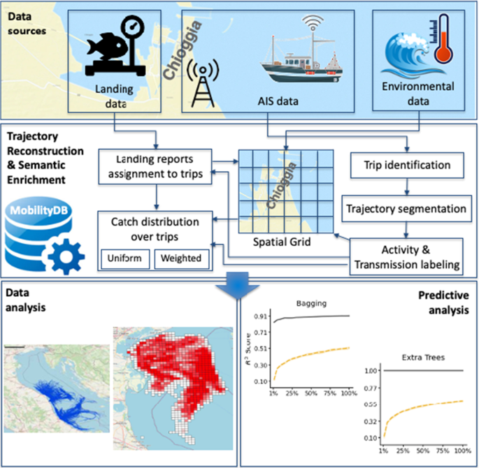
In this paper we model spatio-temporal data describing the fishing activities in the Northern Adriatic Sea over four years. We build, implement and analyze a database based on the fusion of two complementary data sources: trajectories from fishing vessels (obtained from terrestrial Automatic Identification System, or AIS, data feed) and fish catch reports (i.e., the quantity and type of fish caught) of the main fishing market of the area. We present all the phases of the database creation, starting from the raw data and proceeding through data exploration, data cleaning, trajectory reconstruction and semantic enrichment. We implement the database by using MobilityDB, an open source geospatial trajectory data management and analysis platform. Subsequently, we perform various analyses on the resulting spatio-temporal database, with the goal of mapping the fishing activities on some key species, highlighting all the interesting information and inferring new knowledge that will be useful for fishery management. Furthermore, we investigate the use of machine learning methods for predicting the Catch Per Unit Effort (CPUE), an indicator of the fishing resources exploitation in order to drive specific policy design. A variety of prediction methods, taking as input the data in the database and environmental factors such as sea temperature, waves height and Clorophill-a, are put at work in order to assess their prediction ability in this field. To the best of our knowledge, our work represents the first attempt to integrate fishing ships trajectories derived from AIS data, environmental data and catch data for spatio-temporal prediction of CPUE – a challenging task.
中文翻译:
从多方面轨迹到预测分析:以亚得里亚海北部渔船为例
在本文中,我们对描述北亚得里亚海四年内捕鱼活动的时空数据进行建模。我们基于两个互补数据源的融合构建、实施和分析数据库:渔船轨迹(从陆地自动识别系统,或 AIS,数据馈送获得)和捕鱼报告(即捕获的鱼的数量和类型) ) 该地区的主要渔业市场。我们介绍了数据库创建的所有阶段,从原始数据开始,经过数据探索、数据清理、轨迹重建和语义丰富。我们使用开源地理空间轨迹数据管理和分析平台 MobilityDB 来实现数据库。随后,我们对生成的时空数据库进行各种分析,目标是绘制一些关键物种的捕捞活动,突出所有有趣的信息并推断对渔业管理有用的新知识。此外,我们研究使用机器学习方法来预测单位努力渔获量 (CPUE),这是渔业资源开发的指标,以推动特定的政策设计。采用多种预测方法,以数据库中的数据和海温、海浪高度和Clorophill-a等环境因素为输入,以评估其在该领域的预测能力。据我们所知,我们的工作首次尝试整合来自 AIS 数据、环境数据和捕获数据的渔船轨迹,以进行 CPUE 的时空预测——这是一项具有挑战性的任务。


 京公网安备 11010802027423号