Geo-Marine Letters ( IF 2.1 ) Pub Date : 2022-06-23 , DOI: 10.1007/s00367-022-00734-x Daphnie S. Galvez , Svenja Papenmeier , Lasse Sander , Alexander Bartholomä , Karen Helen Wiltshire
|
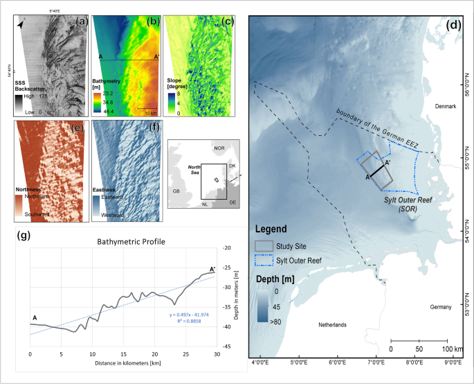
Seafloor sediment mapping traditionally relies on the experience and expertise of practitioners to classify sediment classes based on acoustic backscatter data and ground-truth information. However, recent advancements in automated seafloor mapping present a major development in objective methods that offer practical application for seafloor mapping and monitoring campaigns. In this study, a class-specific approach of ensemble modelling (ensemble mapping) was used to classify the sediment classes of a large-scale seafloor area (1550 km2) in the western Sylt Outer Reef, German North Sea. A pixel-by-pixel comparison of the modelled map and manually digitized map was also conducted to assess the efficiency of the ensemble mapping approach. The resulting seafloor sediment map, with an overall accuracy of 73%, demonstrates five sediment classes that represent most of the seabed of the German North Sea. The manually classified and ensembled maps were 63% identical, but mismatches were observed in the transitional boundaries of soft sediment classes and in stony areas that were not predicted in manual classification. The inconsistencies between the two maps was attributed to the different interpretation of sediment boundaries, the simplification of the sediment classification scheme, and the ability of ensemble mapping to classify more areas than manual classification. This study found that ensemble mapping performs better in characterizing coarse materials and produces maps that are comparable to the maps produced by manual classification, while the production time and degree of subjectivity in the analysis are minimal. Hence, ensemble mapping is a viable alternative to create baseline seafloor sediment maps that can be used for environmental monitoring and resource planning.
中文翻译:
集合测绘作为基线海底沉积物测绘和监测的替代方案
海底沉积物测绘传统上依赖从业者的经验和专业知识,根据声学反向散射数据和地面实况信息对沉积物类别进行分类。然而,自动化海底测绘的最新进展呈现了客观方法的重大发展,为海底测绘和监测活动提供了实际应用。在这项研究中,使用集合建模(集合映射)的特定类别方法对大型海底区域(1550 km 2) 在德国北海的叙尔特外礁西部。还对建模地图和手动数字化地图进行了逐像素比较,以评估集合映射方法的效率。由此产生的海底沉积物地图具有 73% 的整体准确度,展示了代表德国北海大部分海床的五种沉积物类别。人工分类和综合地图有 63% 相同,但在软沉积物类别的过渡边界和人工分类未预测的石质区域中观察到不匹配。两张图的不一致归因于对沉积物边界的不同解释、沉积物分类方案的简化以及集合制图比人工分类分类更多区域的能力。这项研究发现,集成映射在表征粗糙材料方面表现更好,并且生成的地图与人工分类生成的地图相当,而分析中的生成时间和主观程度最小。因此,集合测绘是创建可用于环境监测和资源规划的基线海底沉积物图的可行替代方案。


 京公网安备 11010802027423号