GeoInformatica ( IF 2 ) Pub Date : 2022-09-03 , DOI: 10.1007/s10707-022-00476-z Wenwen Li , Sizhe Wang , Samantha T. Arundel , Chia-Yu Hsu
|
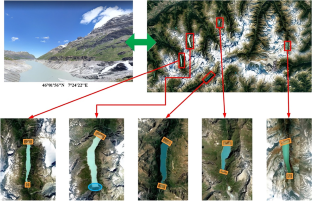
The field of GeoAI or Geospatial Artificial Intelligence has undergone rapid development since 2017. It has been widely applied to address environmental and social science problems, from understanding climate change to tracking the spread of infectious disease. A foundational task in advancing GeoAI research is the creation of open, benchmark datasets to train and evaluate the performance of GeoAI models. While a number of datasets have been published, very few have centered on the natural terrain and its landforms. To bridge this gulf, this paper introduces a first-of-its-kind benchmark dataset, GeoImageNet, which supports natural feature detection in a supervised machine-learning paradigm. A distinctive feature of this dataset is the fusion of multi-source data, including both remote sensing imagery and DEM in depicting spatial objects of interest. This multi-source dataset allows a GeoAI model to extract rich spatio-contextual information to gain stronger confidence in high-precision object detection and recognition. The image dataset is tested with a multi-source GeoAI extension against two well-known object detection models, Faster-RCNN and RetinaNet. The results demonstrate the robustness of the dataset in aiding GeoAI models to achieve convergence and the superiority of multi-source data in yielding much higher prediction accuracy than the commonly used single data source.
中文翻译:
GeoImageNet:用于 GeoAI 和监督机器学习的多源自然特征基准数据集
GeoAI 或地理空间人工智能领域自 2017 年以来经历了快速发展。它已广泛应用于解决环境和社会科学问题,从了解气候变化到追踪传染病的传播。推进 GeoAI 研究的一项基本任务是创建开放的基准数据集,以训练和评估 GeoAI 模型的性能。虽然已经发布了许多数据集,但很少有以自然地形及其地貌为中心的数据集。为了弥合这一鸿沟,本文介绍了首个基准数据集 GeoImageNet,它支持监督机器学习范式中的自然特征检测。该数据集的一个显着特点是融合了多源数据,包括遥感图像和 DEM 来描绘感兴趣的空间对象。这个多源数据集允许 GeoAI 模型提取丰富的空间上下文信息,从而在高精度对象检测和识别中获得更强的信心。图像数据集使用多源 GeoAI 扩展针对两个著名的对象检测模型 Faster-RCNN 和 RetinaNet 进行了测试。结果证明了数据集在帮助 GeoAI 模型实现收敛方面的稳健性以及多源数据在产生比常用的单一数据源更高的预测精度方面的优势。图像数据集使用多源 GeoAI 扩展针对两个著名的对象检测模型 Faster-RCNN 和 RetinaNet 进行了测试。结果证明了数据集在帮助 GeoAI 模型实现收敛方面的稳健性以及多源数据在产生比常用的单一数据源更高的预测精度方面的优势。图像数据集使用多源 GeoAI 扩展针对两个著名的对象检测模型 Faster-RCNN 和 RetinaNet 进行了测试。结果证明了数据集在帮助 GeoAI 模型实现收敛方面的稳健性以及多源数据在产生比常用的单一数据源更高的预测精度方面的优势。


 京公网安备 11010802027423号