当前位置:
X-MOL 学术
›
Photogramm. Rec.
›
论文详情
Our official English website, www.x-mol.net, welcomes your feedback! (Note: you will need to create a separate account there.)
Terrestrial laser scanning for 3D mapping of an alpine ice cave
The Photogrammetric Record ( IF 2.4 ) Pub Date : 2022-12-29 , DOI: 10.1111/phor.12437 Jan Pfeiffer 1, 2 , Martin Rutzinger 1 , Christoph Spötl 1
The Photogrammetric Record ( IF 2.4 ) Pub Date : 2022-12-29 , DOI: 10.1111/phor.12437 Jan Pfeiffer 1, 2 , Martin Rutzinger 1 , Christoph Spötl 1
Affiliation
|
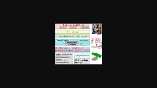
Perennial ice deposits in caves are an underexplored component of the cryosphere preserving a largely untapped archive of long-term changes in landscape and climate whose existence is threatened by climate change. This study demonstrates how terrestrial laser scanning (TLS) can be used to fully and accurately (registration accuracy < 1 cm standard deviation of point differences) assess the geometry of an ice-bearing cave in the Eastern Alps (Tyrol, Austria). Three TLS campaigns and 255 scan positions were used to acquire point clouds with a high sampling density (2 cm average point spacing) in order to minimise shading effects and to assure a precise and highly resolved 3D documentation of the cave. A semi-automated registration and point cloud-processing approach adapted to the site-specific demands ensured a complete and error-minimised assessment of the cave's geometry serving as a solid basis for future quantifications of snow and ice content dynamics. Dominant cave surface structures were investigated by performing a multiscale principal component analysis (PCA) to identify a detailed and computationally efficient basis for future airflow modelling tasks.
中文翻译:

用于高山冰洞 3D 测绘的地面激光扫描
洞穴中的常年冰沉积物是冰冻圈中未被充分探索的组成部分,保存着大量未开发的景观和气候长期变化档案,其存在受到气候变化的威胁。本研究展示了如何使用地面激光扫描 (TLS) 来全面准确地(配准精度 < 1 厘米点差标准偏差)评估东阿尔卑斯山(奥地利蒂罗尔州)的含冰洞穴的几何形状。三个 TLS 活动和 255 个扫描位置用于获取具有高采样密度(2 厘米平均点间距)的点云,以最大限度地减少阴影效果并确保洞穴的精确和高分辨率 3D 文档。适应特定地点需求的半自动配准和点云处理方法确保了对洞穴几何形状的完整和错误最小化评估,为未来冰雪含量动态量化奠定了坚实的基础。通过执行多尺度主成分分析 (PCA) 来研究主要洞穴表面结构,以确定未来气流建模任务的详细和计算有效的基础。
更新日期:2022-12-29
中文翻译:
用于高山冰洞 3D 测绘的地面激光扫描
洞穴中的常年冰沉积物是冰冻圈中未被充分探索的组成部分,保存着大量未开发的景观和气候长期变化档案,其存在受到气候变化的威胁。本研究展示了如何使用地面激光扫描 (TLS) 来全面准确地(配准精度 < 1 厘米点差标准偏差)评估东阿尔卑斯山(奥地利蒂罗尔州)的含冰洞穴的几何形状。三个 TLS 活动和 255 个扫描位置用于获取具有高采样密度(2 厘米平均点间距)的点云,以最大限度地减少阴影效果并确保洞穴的精确和高分辨率 3D 文档。适应特定地点需求的半自动配准和点云处理方法确保了对洞穴几何形状的完整和错误最小化评估,为未来冰雪含量动态量化奠定了坚实的基础。通过执行多尺度主成分分析 (PCA) 来研究主要洞穴表面结构,以确定未来气流建模任务的详细和计算有效的基础。


 京公网安备 11010802027423号