Our official English website, www.x-mol.net, welcomes your feedback! (Note: you will need to create a separate account there.)
Land use/land cover on the South Downs, England in the 1870s: A case study mapping and applying landscape metrics to the Ordnance Survey Parish Books of Reference
The Geographical Journal ( IF 3.384 ) Pub Date : 2023-03-05 , DOI: 10.1111/geoj.12510 Nigel Walford 1
The Geographical Journal ( IF 3.384 ) Pub Date : 2023-03-05 , DOI: 10.1111/geoj.12510 Nigel Walford 1
Affiliation
|
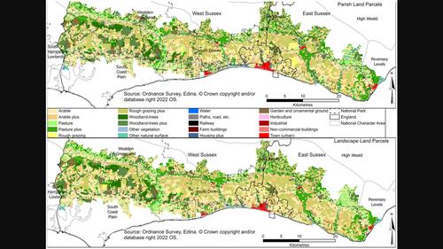
Land use/land cover sits alongside other basic types of information about a country, such as its population and economy. However, in contrast with population data, which have been supplied by the decennial British Population Census since 1801 (apart from 1941), the routine and periodic collection of land-use/land-cover data has proved more challenging. Notable exceptions include the First and Second Land Utilisation surveys of the 1930s and 1960s, and the Countryside Surveys using a stratified sample of 1-km grid squares undertaken periodically since 1984. The focus here is on the land-use/land-cover data collected by the Ordnance Survey from the 1850s to 1880s as part of the cadastral mapping of the country at 1:2500 scale. This information was published in Parish Books of Reference. These documents for parishes covering the South Downs, a National Character Area and National Park, in East and West Sussex provide the attribute data for the land parcels that have been joined to digitised polygons in order map land use/land cover across this area for the mid-1870s. Classification of these data into 20 land-use/land-cover types enabled visual assessment and quantitative analysis using statistical techniques and spatial indices to explore the complexity of the landscape. Having shown the feasibility of mapping land-use/land-cover data for the South Downs, the paper concludes by considering issues involved in extending this work to other counties for which the Books of Reference were published.
中文翻译:

1870 年代英格兰南丘陵的土地利用/土地覆盖:案例研究绘制地形图并将景观指标应用于地形测量教区参考书
土地利用/土地覆盖与一个国家的其他基本类型信息并存,例如人口和经济。然而,与自 1801 年(1941 年除外)以来每十年一次的英国人口普查提供的人口数据相比,常规和定期收集土地利用/土地覆盖数据已被证明更具挑战性。值得注意的例外包括 1930 年代和 1960 年代的第一次和第二次土地利用调查,以及自 1984 年以来定期进行的使用 1 公里方格分层样本的乡村调查。这里的重点是收集的土地利用/土地覆盖数据由 1850 年代至 1880 年代的地形测量局绘制,作为该国 1:2500 比例地籍测绘的一部分。此信息发表在教区参考书中。这些文件适用于覆盖南部丘陵的教区,东萨塞克斯和西萨塞克斯的国家特色区域和国家公园提供了已连接到数字化多边形的地块的属性数据,以便绘制 1870 年代中期该地区的土地利用/土地覆盖图。将这些数据分为 20 种土地利用/土地覆盖类型,利用统计技术和空间指数进行视觉评估和定量分析,以探索景观的复杂性。在展示了绘制南方唐斯土地利用/土地覆盖数据地图的可行性后,本文最后考虑了将这项工作扩展到出版参考书的其他县所涉及的问题。东萨塞克斯和西萨塞克斯提供了已连接到数字化多边形的地块的属性数据,以便绘制 1870 年代中期该地区的土地利用/土地覆盖图。将这些数据分为 20 种土地利用/土地覆盖类型,利用统计技术和空间指数进行视觉评估和定量分析,以探索景观的复杂性。在展示了绘制南方唐斯土地利用/土地覆盖数据地图的可行性后,本文最后考虑了将这项工作扩展到出版参考书的其他县所涉及的问题。东萨塞克斯和西萨塞克斯提供了已连接到数字化多边形的地块的属性数据,以便绘制 1870 年代中期该地区的土地利用/土地覆盖图。将这些数据分为 20 种土地利用/土地覆盖类型,利用统计技术和空间指数进行视觉评估和定量分析,以探索景观的复杂性。在展示了绘制南方唐斯土地利用/土地覆盖数据地图的可行性后,本文最后考虑了将这项工作扩展到出版参考书的其他县所涉及的问题。
更新日期:2023-03-05
中文翻译:
1870 年代英格兰南丘陵的土地利用/土地覆盖:案例研究绘制地形图并将景观指标应用于地形测量教区参考书
土地利用/土地覆盖与一个国家的其他基本类型信息并存,例如人口和经济。然而,与自 1801 年(1941 年除外)以来每十年一次的英国人口普查提供的人口数据相比,常规和定期收集土地利用/土地覆盖数据已被证明更具挑战性。值得注意的例外包括 1930 年代和 1960 年代的第一次和第二次土地利用调查,以及自 1984 年以来定期进行的使用 1 公里方格分层样本的乡村调查。这里的重点是收集的土地利用/土地覆盖数据由 1850 年代至 1880 年代的地形测量局绘制,作为该国 1:2500 比例地籍测绘的一部分。此信息发表在教区参考书中。这些文件适用于覆盖南部丘陵的教区,东萨塞克斯和西萨塞克斯的国家特色区域和国家公园提供了已连接到数字化多边形的地块的属性数据,以便绘制 1870 年代中期该地区的土地利用/土地覆盖图。将这些数据分为 20 种土地利用/土地覆盖类型,利用统计技术和空间指数进行视觉评估和定量分析,以探索景观的复杂性。在展示了绘制南方唐斯土地利用/土地覆盖数据地图的可行性后,本文最后考虑了将这项工作扩展到出版参考书的其他县所涉及的问题。东萨塞克斯和西萨塞克斯提供了已连接到数字化多边形的地块的属性数据,以便绘制 1870 年代中期该地区的土地利用/土地覆盖图。将这些数据分为 20 种土地利用/土地覆盖类型,利用统计技术和空间指数进行视觉评估和定量分析,以探索景观的复杂性。在展示了绘制南方唐斯土地利用/土地覆盖数据地图的可行性后,本文最后考虑了将这项工作扩展到出版参考书的其他县所涉及的问题。东萨塞克斯和西萨塞克斯提供了已连接到数字化多边形的地块的属性数据,以便绘制 1870 年代中期该地区的土地利用/土地覆盖图。将这些数据分为 20 种土地利用/土地覆盖类型,利用统计技术和空间指数进行视觉评估和定量分析,以探索景观的复杂性。在展示了绘制南方唐斯土地利用/土地覆盖数据地图的可行性后,本文最后考虑了将这项工作扩展到出版参考书的其他县所涉及的问题。


 京公网安备 11010802027423号