Boundary-Layer Meteorology ( IF 4.3 ) Pub Date : 2023-03-19 , DOI: 10.1007/s10546-023-00798-x Zhengnong Li , Ou Pu , Yueyue Pan , Bin Huang , Zhefei Zhao , Honghua Wu
|
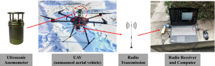
Compared to conventional wind field measurement methods such as wind masts or wind towers, UAV-based measurement is a relatively new approach to making wind field measurements. In the present study, a method for measuring wind field by using a six-rotor UAV mounted with an ultrasonic anemometer was established, and the feasibility thereof in wind field measurement was tested. Firstly, the influence of the UAS fuselage attitude on the accuracy of wind measurement results was analysed by means of wind tunnel testing. The results show that the average wind speed obtained by the UAV anemometry system (UAS) was slightly larger, but the average wind speed obtained by the UAS was consistent with that obtained by the Cobra anemometer after the modification of the fuselage attitude coefficient. Secondly, the wind field measurement results obtained by the UAS and the wind tower were compared, and the revised wind speed, wind direction, turbulence intensity and other parameters obtained by the UAS were found to be consistent with those of the anemometers at the same height on the wind tower. The difference was within 5%, and the longitudinal fluctuating wind power spectra obtained by the two were almost the same, being in good agreement with the Von Karman spectrum. Finally, the UAS was used to measure the wind field characteristic parameters of a certain site, which were compared with the corresponding parameters of national regulations. The feasibility of the UAS in measuring the air wind field was verified. These research results provide a reference for further research into UAV wind measurement methods.
中文翻译:
搭载风速计的多旋翼无人机测量空中风场的研究
与风桅或风塔等传统风场测量方法相比,基于无人机的测量是一种相对较新的风场测量方法。本研究建立了一种六旋翼无人机搭载超声波风速仪测量风场的方法,并测试了其在风场测量中的可行性。首先,通过风洞试验分析无人机机身姿态对测风结果精度的影响。结果表明,无人机测速系统(UAS)获取的平均风速略大,但UAS获取的平均风速与Cobra风速计在修改机身姿态系数后获取的平均风速一致。第二,将无人机与风塔获得的风场测量结果进行对比,发现无人机获得的修正后的风速、风向、湍流强度等参数与地面上同一高度的风速计一致。风塔。差异在5%以内,两者得到的纵向脉动风功率谱几乎相同,与冯卡门谱吻合较好。最后,利用无人机对某场地的风场特征参数进行实测,并与国家规定的相应参数进行对比。验证了无人机测量空中风场的可行性。这些研究成果为无人机测风方法的进一步研究提供了参考。发现无人机修正后的风速、风向、湍流强度等参数与风塔同高度风速计一致。差异在5%以内,两者得到的纵向脉动风功率谱几乎相同,与冯卡门谱吻合较好。最后,利用无人机对某场地的风场特征参数进行实测,并与国家规定的相应参数进行对比。验证了无人机测量空中风场的可行性。这些研究成果为无人机测风方法的进一步研究提供了参考。发现无人机修正后的风速、风向、湍流强度等参数与风塔同高度风速计一致。差异在5%以内,两者得到的纵向脉动风功率谱几乎相同,与冯卡门谱吻合较好。最后,利用无人机对某场地的风场特征参数进行实测,并与国家规定的相应参数进行对比。验证了无人机测量空中风场的可行性。这些研究成果为无人机测风方法的进一步研究提供了参考。发现无人机获取的湍流强度等参数与风塔上相同高度的风速计一致。差异在5%以内,两者得到的纵向脉动风功率谱几乎相同,与冯卡门谱吻合较好。最后,利用无人机对某场地的风场特征参数进行实测,并与国家规定的相应参数进行对比。验证了无人机测量空中风场的可行性。这些研究成果为无人机测风方法的进一步研究提供了参考。发现无人机获取的湍流强度等参数与风塔上相同高度的风速计一致。差异在5%以内,两者得到的纵向脉动风功率谱几乎相同,与冯卡门谱吻合较好。最后,利用无人机对某场地的风场特征参数进行实测,并与国家规定的相应参数进行对比。验证了无人机测量空中风场的可行性。这些研究成果为无人机测风方法的进一步研究提供了参考。两者得到的纵向脉动风功率谱几乎相同,与冯卡门谱吻合较好。最后,利用无人机对某场地的风场特征参数进行实测,并与国家规定的相应参数进行对比。验证了无人机测量空中风场的可行性。这些研究成果为无人机测风方法的进一步研究提供了参考。两者得到的纵向脉动风功率谱几乎相同,与冯卡门谱吻合较好。最后,利用无人机对某场地的风场特征参数进行实测,并与国家规定的相应参数进行对比。验证了无人机测量空中风场的可行性。这些研究成果为无人机测风方法的进一步研究提供了参考。


 京公网安备 11010802027423号