Arid Ecosystems Pub Date : 2023-03-30 , DOI: 10.1134/s2079096123010171 V. G. Yuferev , V. A. Silova , N. A. Tkachenko
|
Abstract
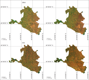
Geoinformation technologies for assessing the desertification of arid territories provide the determination of the spatial position of research objects, as well as the fixation of changes in the territories in the spatio-temporal aspect under the influence of climatic and anthropogenic factors that determine such changes. Remote, spatio-temporal monitoring consists in mapping desertification areas with accurate geo-referencing of objects and determining the changes that have occurred on them over time (Mariam Akhtar-Schuster, 2020). The assessment of the degree of desertification is based on the classification of desertification types and the methodology of remote studies of degradation sites and geoinformation technologies (Yuferev, 2007). Taking the criteria of ecological state zones (norm, risk, crisis, and disaster) for various types of agricultural land (Vinogradov, 1984) as a basis, we determined the criteria for remote monitoring of environmental disaster zones using up-to-date satellite images on the territory of the Republic of Kalmykia. The use of remote methods for desertification assessment for monitoring makes it possible to identify spatial changes in the monitoring area when the level of impact of anthropogenic and climatic factors changes. Mathematical and statistical processing of the results obtained in spatio-temporal studies make it possible to identify the functional relationships between the area of desertification and the magnitude of the natural and anthropogenic factors, on the basis of which it becomes possible to develop a mathematical model of such changes. Such a model reflects the probable development of the area of desertification, depending on the actual combination of the most significant factors, thus, the choice of such factors is important in modeling. Modeling the degree of degradation is based on an assessment of the size of areas subject to a certain degree of degradation and a mathematical description of the processes of changing their state. As a result, the desertification areas and changes in the areas of these zones were determined in the study area. The monitoring of desertification according to remote survey data of the territory of Kalmykia made it possible to determine an increase in areas subject to desertification by almost 4 times, from 750 to 3000 thousand hectares from 1984 to 2020.
中文翻译:
卡尔梅克沙漠化远程监测
摘要
用于评估干旱地区荒漠化的地理信息技术可以确定研究对象的空间位置,以及在决定这种变化的气候和人为因素的影响下,在时空方面确定地区的变化。远程时空监测包括通过准确的对象地理参考绘制荒漠化区域,并确定它们随时间发生的变化(Mariam Akhtar-Schuster,2020 年)。荒漠化程度的评估基于荒漠化类型的分类以及退化地点和地理信息技术的远程研究方法(Yuferev,2007)。以生态状态区(常态、风险、危机、和灾难)的各种类型的农业用地(Vinogradov,1984)作为基础,我们确定了使用卡尔梅克共和国领土上的最新卫星图像对环境灾害区进行远程监测的标准。使用远程荒漠化评估方法进行监测,可以在人为和气候因素的影响水平发生变化时识别监测区域的空间变化。对时空研究中获得的结果进行数学和统计处理,可以确定荒漠化面积与自然和人为因素的大小之间的函数关系,在此基础上可以开发一个数学模型这样的变化。这种模型反映了荒漠化面积的可能发展,取决于最显着因素的实际组合,因此,这些因素的选择在建模中很重要。对退化程度建模是基于对受一定退化程度影响的区域大小的评估以及对其状态变化过程的数学描述。由此确定了研究区的荒漠化面积及其面积变化。根据卡尔梅克领土远程调查数据进行的荒漠化监测,可以确定从 1984 年到 2020 年,荒漠化面积增加了近 4 倍,从 750 公顷增加到 300 万公顷。这些因素的选择在建模中很重要。对退化程度建模是基于对受一定退化程度影响的区域大小的评估以及对其状态变化过程的数学描述。由此确定了研究区的荒漠化面积及其面积变化。根据卡尔梅克领土远程调查数据进行的荒漠化监测,可以确定从 1984 年到 2020 年,荒漠化面积增加了近 4 倍,从 750 公顷增加到 300 万公顷。这些因素的选择在建模中很重要。对退化程度建模是基于对受一定退化程度影响的区域大小的评估以及对其状态变化过程的数学描述。由此确定了研究区的荒漠化面积及其面积变化。根据卡尔梅克领土远程调查数据进行的荒漠化监测,可以确定从 1984 年到 2020 年,荒漠化面积增加了近 4 倍,从 750 公顷增加到 300 万公顷。由此确定了研究区的荒漠化面积及其面积变化。根据卡尔梅克领土远程调查数据进行的荒漠化监测,可以确定从 1984 年到 2020 年,荒漠化面积增加了近 4 倍,从 750 公顷增加到 300 万公顷。由此确定了研究区的荒漠化面积及其面积变化。根据卡尔梅克领土远程调查数据进行的荒漠化监测,可以确定从 1984 年到 2020 年,荒漠化面积增加了近 4 倍,从 750 公顷增加到 300 万公顷。


 京公网安备 11010802027423号