当前位置:
X-MOL 学术
›
Trans. Instit. Br. Geogr.
›
论文详情
Our official English website, www.x-mol.net, welcomes your feedback! (Note: you will need to create a separate account there.)
Revealing vertical geopolitics: Quantifying the volume of militarised restricted airspaces in the USA using GIS
Transactions of the Institute of British Geographers ( IF 3.445 ) Pub Date : 2023-05-17 , DOI: 10.1111/tran.12614 David G. Havlick 1 , Thi Hong Diep Dao 1
Transactions of the Institute of British Geographers ( IF 3.445 ) Pub Date : 2023-05-17 , DOI: 10.1111/tran.12614 David G. Havlick 1 , Thi Hong Diep Dao 1
Affiliation
|
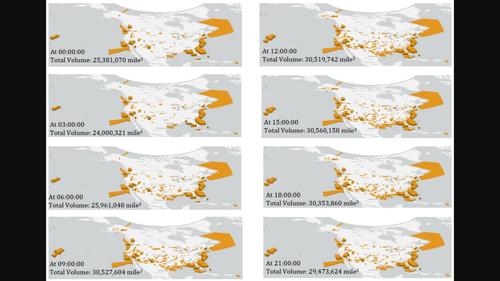
The US military maintains significant control of land and sea territory, both domestically and internationally. Extending vertically, the US military also restricts vast areas of airspace to protect its interests in training, testing, surveillance, and security. In order to convey the multidimensional extent of spatial control maintained by the US Department of Defence, in this paper we critically assess, calculate, and depict the volume of militarised restricted airspaces in the USA. Airspace restrictions vary across days, times, and spatial extent, requiring an analysis and volumetric visualisation that can account for three- and four-dimensional change. Applying this analysis casts the extent and variability of US military spatial control in fuller relief and makes visible new aspects of a vertical geopolitics. The research brings important new insights and methods to bear on little-examined attributes of US militarisation and engages increasingly relevant questions about militarised airspace and contestable claims on near space.
中文翻译:

揭示垂直地缘政治:使用 GIS 量化美国军事限制空域的体积
美国军队在国内和国际上保持着对陆地和海洋领土的重要控制。纵向延伸,美军还限制大片空域,以保护其训练、测试、监视和安全利益。为了传达美国国防部维持的空间控制的多维范围,在本文中,我们批判性地评估、计算和描述了美国军事化限制空域的体积。空域限制随日期、时间和空间范围的不同而变化,需要进行分析和体积可视化来解释三维和四维的变化。应用这一分析可以更充分地揭示美国军事空间控制的范围和可变性,并使垂直地缘政治的新方面变得可见。这项研究为美国军事化的鲜为人知的属性带来了重要的新见解和方法,并涉及了有关军事化空域和对邻近空间有争议的主张的日益相关的问题。
更新日期:2023-05-17
中文翻译:
揭示垂直地缘政治:使用 GIS 量化美国军事限制空域的体积
美国军队在国内和国际上保持着对陆地和海洋领土的重要控制。纵向延伸,美军还限制大片空域,以保护其训练、测试、监视和安全利益。为了传达美国国防部维持的空间控制的多维范围,在本文中,我们批判性地评估、计算和描述了美国军事化限制空域的体积。空域限制随日期、时间和空间范围的不同而变化,需要进行分析和体积可视化来解释三维和四维的变化。应用这一分析可以更充分地揭示美国军事空间控制的范围和可变性,并使垂直地缘政治的新方面变得可见。这项研究为美国军事化的鲜为人知的属性带来了重要的新见解和方法,并涉及了有关军事化空域和对邻近空间有争议的主张的日益相关的问题。


 京公网安备 11010802027423号