Applied Spatial Analysis and Policy ( IF 2.043 ) Pub Date : 2023-05-24 , DOI: 10.1007/s12061-023-09519-w Emad Soroori , Behzad Kiani , Soraya Ghasemi , Alireza Mohammadi , Hamidreza Shabanikiya , Robert Bergquist , Fatemeh Kiani , Hossein Tabatabaei-Jafari
|
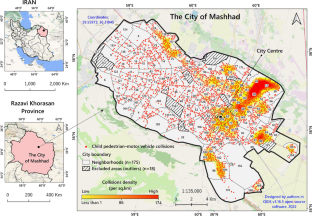
This study examined the relationship between environmental and socioeconomic factors and the number of motor vehicle collisions involving young pedestrians. The research encompassed urban neighbourhoods as well as an entire metropolitan area and analyzed data from 7,028 motor vehicle collisions that involved pedestrians aged 18 years or younger, occurring between 2015 and 2019 in the city of Mashhad, Iran. Thirteen indices related to socioeconomic and built environmental factors were quantified at the neighbourhood level. To model the relationship between these explanatory factors and the number of collisions investigated, Poisson and negative binomial models were developed using the geographically weighted regression (GWR) technique. The GWR was used to account for the impact of location on the association between explanatory factors and the count of collisions. The study found that the population of young people, road area ratio, main road intersection ratio, average maximum speed limit, non-motorized travels, sidewalk area ratio, sidewalk disconnections, number of schools, unemployment ratio, illiteracy rate, and open space ratio were significantly associated with child pedestrian-motor vehicle collisions. However, these associations were not uniform across the entire study area. It is possible that unknown factors or an unknown interaction of known factors in different parts of the urban area may have influenced the observed associations.
中文翻译:
城市邻里特征与儿童行人-机动车碰撞之间的空间关联
这项研究探讨了环境和社会经济因素与涉及年轻行人的机动车碰撞数量之间的关系。该研究涵盖了城市社区以及整个大都市区,并分析了 2015 年至 2019 年间发生在伊朗马什哈德市的 7,028 起涉及 18 岁或以下行人的机动车碰撞数据。与社会经济和建筑环境因素相关的十三个指数在社区层面进行了量化。为了对这些解释因素与所调查的碰撞次数之间的关系进行建模,使用地理加权回归 (GWR) 技术开发了泊松模型和负二项式模型。GWR 用于解释位置对解释因素与碰撞计数之间关联的影响。研究发现,年轻人口、道路面积率、主干道交叉口率、平均最高限速、非机动车出行、人行道面积率、人行道断线率、学校数量、失业率、文盲率、空地率与儿童行人与机动车碰撞显着相关。然而,这些关联在整个研究区域并不统一。城市地区不同地区的未知因素或已知因素的未知相互作用可能影响了观察到的关联。


 京公网安备 11010802027423号