Paddy and Water Environment ( IF 2.2 ) Pub Date : 2023-05-28 , DOI: 10.1007/s10333-023-00934-w Divya Vijayan V , Dnyaneshwar Arjun Madane , Dipanwita Haldar
|
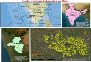
Crop identification and acreage estimation are always challenges for passive remote sensing in cloudy environments, especially during the rainy season. Microwave remote sensing data, with its availability and advantages of cloud penetration, can offer a solution to this problem. In the present study, a dual-pole polarization Sentinel-1 (C-band) SAR dataset was used for the assessment of the paddy temporal growth stage in the Alathur block of Kerala, India. The acreage estimation of coconut, fallow, mixed trees, paddy, rubber, plantation, paddy-coconut, and plantation fallow classes were also carried out using ArcGIS software. The multi-temporal data from June 2021 to October 2021 is openly accessible from the European Space Agency (ESA) via the Sentinel-1. The image was preprocessed for radiometric corrections, speckle filtering, terrain correction, and co-registration, and was finally converted from a linear to a decibel (dB) domain using ESA (SNAP software). The crop discrimination of paddy and other classes was also classified by using the decision tree rule (DTR), K-nearest neighbors, minimum distance (MD), and random forest (RF) classifiers. The results revealed that during the early stage of the paddy crop, specular reflection occurred, which enabled a low backscatter signature of − 18.45 to − 10.9 dB in VH (vertical transmit and horizontal receive) and in VV (vertical transmit and vertical receive) polarization, and with each growth stage of the crop, the backscatter varied. However, there was no significant variation observed for coconut (− 15.02 dB) in VH (vertical transmit and horizontal receive) and (− 8.67 dB) in VV (vertical transmit and vertical receive) and for Rubber (− 14.57 dB) in VH (vertical transmit and horizontal receive) and (− 7.78 dB) in VV (vertical transmit and vertical receive) as compared to paddy field. The results obtained for paddy and other classes from different classifiers revealed that random forest (RF) and K-nearest neighbor classifications gave 95.0 percent and 94.0 percent accuracy for the classification of paddy, respectively, as compared to decision tree rule (DTR) and minimum distance classification.
中文翻译:
使用机器学习算法对印度喀拉拉邦 Palakkad 区 Alathur 区块的多时相 Sentinel-1A(C 波段)数据进行季风水稻作物鉴别
作物识别和种植面积估算一直是多云环境中被动遥感的挑战,尤其是在雨季。微波遥感数据以其可用性和透云优势,可以解决这一问题。在本研究中,双极偏振 Sentinel-1(C 波段)SAR 数据集用于评估印度喀拉拉邦 Alathur 区块的水稻时间生长阶段。还使用 ArcGIS 软件对椰子、休耕、混交树、水稻、橡胶、种植园、水稻-椰子和种植园休耕类的面积进行了估算。2021 年 6 月至 2021 年 10 月的多时相数据可通过 Sentinel-1 从欧洲航天局 (ESA) 公开获取。图像经过预处理以进行辐射校正、散斑过滤、地形校正和共同注册,并最终使用 ESA(SNAP 软件)从线性域转换为分贝 (dB) 域。还使用决策树规则 (DTR)、K 最近邻、最小距离 (MD) 和随机森林 (RF) 分类器对水稻和其他类别的作物判别进行了分类。结果显示,在水稻作物的早期阶段,发生了镜面反射,这使得 VH(垂直发射和水平接收)和 VV(垂直发射和垂直接收)极化中的反向散射特征为 − 18.45 至 − 10.9 dB ,并且随着作物的每个生长阶段,反向散射都不同。然而,在 VH(垂直发射和水平接收)和(− 8。与稻田相比,VV(垂直发射和垂直接收)中的 67 dB)和 VH(垂直发射和水平接收)中的 Rubber (− 14.57 dB) 以及 VV(垂直发射和垂直接收)中的 (− 7.78 dB)。从不同分类器获得的水稻和其他类别的结果表明,与决策树规则 (DTR) 和最小距离分类。


 京公网安备 11010802027423号