Applied Spatial Analysis and Policy ( IF 2.043 ) Pub Date : 2023-06-01 , DOI: 10.1007/s12061-023-09518-x Vasco Diogo 1 , Chris Jacobs-Crisioni 2 , Claudia Baranzelli 2 , Carlo Lavalle 2
|
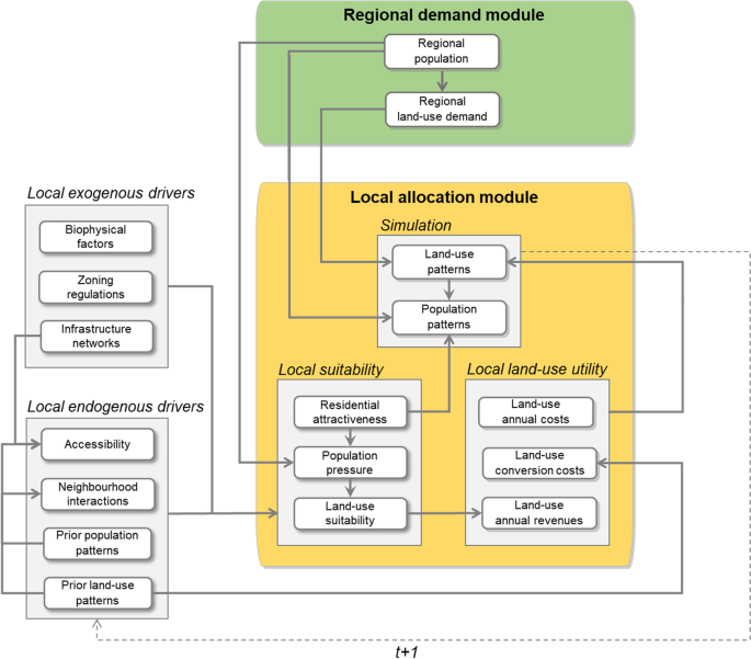
Spatial models jointly simulating population and land-use change provide support for policy-making, by allowing to explore territorial developments under alternative scenarios and resulting impacts in the environment, economy and society. However, their ability to reproduce observed spatial patterns is rarely evaluated through model validation. This lack of insight prevents researchers and policy-makers of fully grasping the ability of existing models to provide sensible projections of future land use and population density. In this article, we address this gap by performing a model validation of the LUISA Territorial Modelling Platform, a spatial model jointly simulating population and land use at a fine resolution (100 m) in the European Union and United Kingdom. In particular, we compare observed and simulated patterns of population and urban residential land-use change for the period of 1990–2015, and evaluate the model performance according to different degrees of urbanisation. The results show that model performance can vary depending on the context, even when the same data and methods are uniformly applied. The model performed consistently well in urban areas characterized by compact urban growth, but poorly where residential development occurred predominantly in scattered patterns across rural areas. Overall, the model tends to favour the formation of densely populated, highly accessible urban conglomerations, which often do not entirely correspond to the observed patterns. Based on the validation results, we propose directions for further model improvement and development. Model validation should be regarded as a critical step, and an integral part, in the process of developing models for policy support.
中文翻译:
人口和城市土地利用的综合空间模拟:泛欧模型验证
联合模拟人口和土地利用变化的空间模型可以探索替代情景下的领土发展及其对环境、经济和社会的影响,从而为政策制定提供支持。然而,它们再现观察到的空间模式的能力很少通过模型验证来评估。由于缺乏洞察力,研究人员和政策制定者无法充分掌握现有模型对未来土地利用和人口密度进行合理预测的能力。在本文中,我们通过对 LUISA 领土建模平台进行模型验证来解决这一差距,该平台是一个空间模型,以高分辨率 (100 m) 联合模拟欧盟和英国的人口和土地利用。特别是,我们比较了1990-2015年期间人口和城市居住用地变化的观测模式和模拟模式,并根据不同的城市化程度评估了模型的性能。结果表明,即使统一应用相同的数据和方法,模型性能也会根据上下文而变化。该模型在以紧凑的城市增长为特征的城市地区表现始终良好,但在住宅开发主要以分散的方式分布在农村地区的地区表现不佳。总体而言,该模型倾向于形成人口稠密、交通便利的城市群,但这些城市群通常并不完全符合观察到的模式。根据验证结果,我们提出进一步模型改进和开发的方向。模型验证应被视为开发政策支持模型过程中的关键步骤和不可或缺的一部分。


 京公网安备 11010802027423号