Journal of Seismology ( IF 1.6 ) Pub Date : 2023-07-18 , DOI: 10.1007/s10950-023-10159-3 H. Amini
|
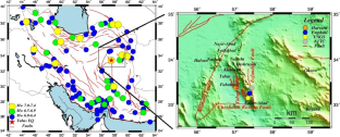
Estimating the macroseismic parameters of earthquakes such as location, magnitude, and fault orientation can be helpful to complete the earthquake catalogs, especially on historical ones or the ones whose parameters were estimated with low accuracy. This study aims to estimate the macroseismic parameters of Tabas earthquake (1978.09.16) using its reported descriptions, Macroseismic Data Points (MDPs). MDPs include any descriptions of earthquake effects on building damages and environmental effects of each location affected by the earthquake. Macroseismic dataset of Tabas earthquake is collected from different documents. Thus, this dataset is used to estimate the macroseismic parameters of this earthquake: macroseismic location, magnitude, intensity, and source parameters. Results estimate the macroseismic epicenter of this earthquake at 33.49°N–56.94°E with the moment magnitude, Mw, 7.1 and the maximum macroseismic intensity value XI in both EMS and ESI intensity scales. Its estimated source orientation is consistent to Tabas fault system in the direction NNW-SSE with the strike, length, and width value of the source in 166.8°, 55.8 ± 7.5 km, and 18.2 ± 1.4 km, respectively. Moreover, for future studies, the locations near Khosro Abad, close to the macroseismic epicenter of this earthquake, are suggested for the next field studies, sampling the sediments related to the past evidences and dating them.
中文翻译:
1978 年 9 月 16 日(伊朗东部)Tabas-e-Golshan 地震的断层参数,基于宏观地震观测,并提供测年地点以改进数据集
估算地震的位置、震级、断层走向等宏观地震参数,有助于完善地震目录,特别是历史地震或参数估算精度较低的地震目录。本研究旨在利用其报告的描述、宏观地震数据点(MDP)来估计塔巴斯地震(1978.09.16)的宏观地震参数。MDP 包括对地震对建筑物损坏的影响以及受地震影响的每个地点的环境影响的任何描述。塔巴斯地震的宏观地震数据集是从不同的文献中收集的。因此,该数据集用于估计本次地震的宏观地震参数:宏观地震位置、震级、强度和震源参数。结果估计本次地震的宏观震中位于北纬 33.49°N–56。94°E,矩震级 Mw 7.1 以及 EMS 和 ESI 强度等级中的最大宏观地震强度值 XI。其估计的震源方位与NNW-SSE方向的塔巴斯断层系一致,震源走向、长度和宽度值分别为166.8°、55.8 ± 7.5 km和18.2 ± 1.4 km。此外,对于未来的研究,建议在科斯罗阿巴德附近靠近本次地震震中的地点进行下一次实地研究,对与过去证据相关的沉积物进行采样并进行年代测定。分别为 5 公里和 18.2 ± 1.4 公里。此外,对于未来的研究,建议在科斯罗阿巴德附近靠近本次地震震中的地点进行下一次实地研究,对与过去证据相关的沉积物进行采样并进行年代测定。分别为 5 公里和 18.2 ± 1.4 公里。此外,对于未来的研究,建议在科斯罗阿巴德附近靠近本次地震震中的地点进行下一次实地研究,对与过去证据相关的沉积物进行采样并进行年代测定。


 京公网安备 11010802027423号