当前位置:
X-MOL 学术
›
WIREs Water
›
论文详情
Our official English website, www.x-mol.net, welcomes your feedback! (Note: you will need to create a separate account there.)
The development of a hydrogeological conceptual model of groundwater and surface water flows in the Silala River Basin
WIREs Water ( IF 8.2 ) Pub Date : 2023-07-18 , DOI: 10.1002/wat2.1676 Denis Peach 1, 2 , Adam Taylor 3
WIREs Water ( IF 8.2 ) Pub Date : 2023-07-18 , DOI: 10.1002/wat2.1676 Denis Peach 1, 2 , Adam Taylor 3
Affiliation
|
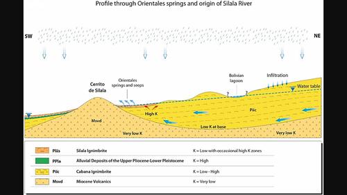
From 1999 a dispute between Bolivia and Chile concerning the status and use of the Silala River developed. In 2016 it was taken before the International Court of Justice. Over time, a key disagreement between the parties emerged, concerning artificial channels in the headwater wetlands of the Silala River in Bolivia and their impact on the river and groundwater discharge from Bolivia to Chile. To quantify this, a numerical groundwater model was developed by Chile, requiring a hydrogeological conceptual model of the Silala River Basin, reviewed here. This focussed on understanding the groundwater system and its interactions with the Silala River. The data and information used to gain this understanding included geological mapping, drilling, satellite imagery interpretation, geophysical surveys, hydrogeochemical analyses, groundwater level monitoring, surface flow monitoring, and groundwater pumping tests. These were focussed along the course of the river and wetlands. A three-dimensional geological model of the Silala Basin was based on these investigations. The groundwater model area covers the topographic catchment, plus three adjacent closed (endorheic) topographical catchments to the northeast, which together form the groundwater catchment of the Silala River. The main deep regional aquifer is found in ignimbrite pyroclastic rocks and an interbedded alluvial deposit, but secondary perched aquifers on the flanks of the Silala River ravine contribute to the complexity. Although uncertainty remains, the hydrogeological conceptual model describes the main observed features of the system in a scientifically sound and coherent manner, with appropriate detail to support a credible numerical model.
中文翻译:

锡拉拉河流域地下水和地表水流水文地质概念模型的开发
从1999年起,玻利维亚和智利之间就锡拉拉河的地位和使用产生了争端。 2016年,该案被提交国际法院审理。随着时间的推移,双方就玻利维亚锡拉拉河源头湿地的人工渠道及其对从玻利维亚到智利的河流和地下水排放的影响出现了关键分歧。为了量化这一点,智利开发了一个地下水数值模型,需要锡拉拉河流域的水文地质概念模型,此处进行了综述。重点是了解地下水系统及其与锡拉拉河的相互作用。用于获得这种了解的数据和信息包括地质测绘、钻探、卫星图像解释、地球物理调查、水文地球化学分析、地下水位监测、地表流量监测和地下水抽水测试。这些集中在河流和湿地沿线。锡拉拉盆地的三维地质模型就是基于这些调查。地下水模型区覆盖地形流域,加上东北部三个相邻的封闭(内流)地形流域,共同构成锡拉拉河地下水流域。主要的深层区域含水层存在于火成岩火山碎屑岩和互层冲积矿床中,但锡拉拉河谷两侧的次生栖息含水层也造成了复杂性。尽管仍然存在不确定性,但水文地质概念模型以科学合理和连贯的方式描述了系统的主要观测特征,并提供了适当的细节来支持可信的数值模型。
更新日期:2023-07-18
中文翻译:
锡拉拉河流域地下水和地表水流水文地质概念模型的开发
从1999年起,玻利维亚和智利之间就锡拉拉河的地位和使用产生了争端。 2016年,该案被提交国际法院审理。随着时间的推移,双方就玻利维亚锡拉拉河源头湿地的人工渠道及其对从玻利维亚到智利的河流和地下水排放的影响出现了关键分歧。为了量化这一点,智利开发了一个地下水数值模型,需要锡拉拉河流域的水文地质概念模型,此处进行了综述。重点是了解地下水系统及其与锡拉拉河的相互作用。用于获得这种了解的数据和信息包括地质测绘、钻探、卫星图像解释、地球物理调查、水文地球化学分析、地下水位监测、地表流量监测和地下水抽水测试。这些集中在河流和湿地沿线。锡拉拉盆地的三维地质模型就是基于这些调查。地下水模型区覆盖地形流域,加上东北部三个相邻的封闭(内流)地形流域,共同构成锡拉拉河地下水流域。主要的深层区域含水层存在于火成岩火山碎屑岩和互层冲积矿床中,但锡拉拉河谷两侧的次生栖息含水层也造成了复杂性。尽管仍然存在不确定性,但水文地质概念模型以科学合理和连贯的方式描述了系统的主要观测特征,并提供了适当的细节来支持可信的数值模型。


 京公网安备 11010802027423号