Environmental and Ecological Statistics ( IF 3.8 ) Pub Date : 2023-07-19 , DOI: 10.1007/s10651-023-00571-w Perla Rivadeneyra García , Luisa Scaccia , Luca Salvati
|
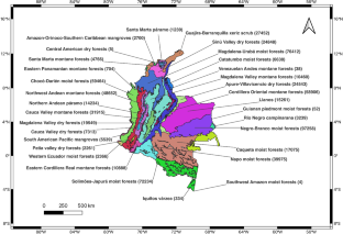
Accurate forest assessment is essential to detect and tackle deforestation, especially in emerging economies. In Colombia, three different geo-spatial data sources are available for forest monitoring: the European Space Agency (ESA), the Institute for Hydrology, Meteorology and Environmental Studies (IDEAM), and the Global Forest Change Data (GFCD) from the University of Maryland. These information sources have distinct characteristics, purposes, and coverage, and their peculiarities can lead to marked differences in the results when they are used to produce forest cover maps. In this study, we determine the optimal forest threshold for GFCD and assess the accuracy of the three data sources in mapping forests, on the basis of a stratified sample of sites, with Colombian ecoregions used as strata. At each site, the classification into forest or non-forest, according to one of the sources, is compared with reference data collected through Google Earth imagery and landscape photographs. Accuracy measures are produced at both the ecoregion and national level. IDEAM and GFCD prove to be quite accurate in most cases, and each of them turns out to be the best forest map in about half of the ecoregions. GFCD’s optimal threshold is found to be equal to 90% in almost all those ecoregions for which it represents the best performing data set.
中文翻译:
哥伦比亚三个森林覆盖数据库的准确性评估
准确的森林评估对于发现和解决森林砍伐问题至关重要,特别是在新兴经济体。在哥伦比亚,三种不同的地理空间数据源可用于森林监测:欧洲航天局 (ESA)、水文、气象和环境研究所 (IDEAM) 以及马里兰大学的全球森林变化数据 (GFCD)。这些信息源具有不同的特征、目的和覆盖范围,它们的特殊性可能导致在用于制作森林覆盖图时结果存在显着差异。在本研究中,我们以哥伦比亚生态区为分层,以场地分层样本为基础,确定了 GFCD 的最佳森林阈值,并评估了三个数据源在绘制森林图时的准确性。在每个站点,据一位消息来源称,森林或非森林的分类是与通过谷歌地球图像和景观照片收集的参考数据进行比较的。准确度测量是在生态区和国家层面上制定的。事实证明,IDEAM 和 GFCD 在大多数情况下都相当准确,并且它们都被证明是大约一半生态区的最佳森林地图。在几乎所有代表最佳表现数据集的生态区域中,发现 GFCD 的最佳阈值等于 90%。事实证明,每张地图都是大约一半生态区的最佳森林地图。在几乎所有代表最佳表现数据集的生态区域中,发现 GFCD 的最佳阈值等于 90%。事实证明,每张地图都是大约一半生态区的最佳森林地图。在几乎所有代表最佳表现数据集的生态区域中,发现 GFCD 的最佳阈值等于 90%。


 京公网安备 11010802027423号