Networks and Spatial Economics ( IF 2.4 ) Pub Date : 2023-07-21 , DOI: 10.1007/s11067-023-09596-x Jizhe Zhou , Yanhong Jiang , Shaolin Niu , Lan Li , Weijia Li , Yahui Zhang , Dongyang Liu
|
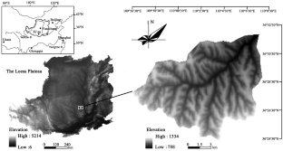
Under the influence of the conversion of farmland to forest and rapid urbanization, the traditional rural settlements in the hilly and gully region of the loess plateau are experiencing problems, such as hollowing and decline, due to the difficulty in adapting to changes in social relations. With Angou Watershed as an example, a research framework of “gravity identification-network evaluation-spatial optimization” is constructed, which is used to analyze the characteristics of the network as a whole, regions and nodes. In addition, social network analysis is employed to reveal the spatial pattern of rural settlements in the watershed. According to the findings, the lack of close ties of communities within the watershed makes it difficult to achieve close social interactions and services. Divided by region, 8 settlement groups are formed, but there is a lack of cohesion and cooperation among the settlement groups. The proportion of marginal settlement nodes is as high as 39.13%, resulting in the serious shortage of motivation for village development. Finally, a three-level rural settlement system is proposed, and 8 hub villages are added, which play a connecting role of tableland-type villages. In order to form a complete industrial chain, the central settlement processing industry is intensively cultivated. Through the reconstruction of the four cluster development groups, the north-south connection of the watershed is strengthened. By defining the number of villages of three types of leader, key position and explorer, the development direction is clarified. This study not only has a significant guiding role in the coordinated development of rural settlements in small watersheds in the hilly and gully areas of the loess plateau, but also provides an important basis for regional urban and rural overall planning, village layout, as well as resource allocation and construction.
中文翻译:
基于社会网络分析的小流域乡村聚落空间优化
在退耕还林和快速城镇化的影响下,黄土高原丘陵沟壑地区的传统乡村聚落因难以适应社会关系的变化而出现空心化、衰落等问题。以安沟流域为例,构建了“重力识别-网络评价-空间优化”的研究框架,对网络整体、区域和节点特征进行分析。此外,利用社会网络分析揭示流域农村聚落的空间格局。调查结果显示,流域内社区缺乏密切联系,难以实现密切的社会互动和服务。按区域划分,形成8个聚居组团,但定居点团体之间缺乏凝聚力和合作。边缘聚落节点比例高达39.13%,导致村庄发展动力严重不足。最后提出三级乡村聚落体系,新增8个中心村,发挥台地型村庄的衔接作用。形成完整产业链,精耕中央结算加工业。通过四个集群发展组团的重建,加强流域南北联系。通过界定领导者、关键岗位、探索者三类村庄数量,明确发展方向。


 京公网安备 11010802027423号