Applied Spatial Analysis and Policy ( IF 2.043 ) Pub Date : 2023-08-02 , DOI: 10.1007/s12061-023-09533-y Kejiang Qian , Yijing Li
|
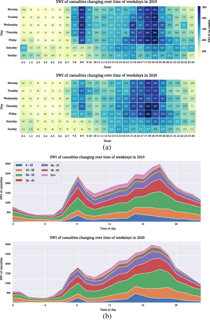
In the aim to provide evidence for deployment policies towards post-pandemic safer recovery from COVID-19, this study investigated the spatiotemporal patterns of age-involved car crashes and affecting factors, upon answering two main research questions: (1) “What are spatiotemporal patterns of car crashes and any observed changes in two years, 2019 and 2020, in London, and waht were the influential factors for these crashes?”; (2) “What are spatiotemporal patterns of casualty by age, and how do people’s daily activities affect the patterns pre- and during the pandemic”? Three approaches, spatial analysis (network Kernel Density Estimation, NetKDE), factor analysis, and spatiotemporal data mining (tensor decomposition), had been implemented to identify the temporal patterns of car crashes, detect hot spots, and to understand the effect on citizens’ daily activity on crash patterns pre- and during the pandemic. It had been found from the study that car crashes mainly clustered in the central part of London, especially busier areas around denser hubs of point-of-interest (POIs); the POIs, as an indicator for citizens’ daily activities and travel behaviours, can be of help to analyze their relationships with crash patterns, upon further assessment on interactions through the geographical detector; the casualty patterns varied by age group, with distinctive relationships between POIs and crash pattern for corresponding age group categorised. In all, the paper introduced new approaches for an in-depth analysis of car crashes and their casualty patterns in London to support London’s safer recovery from the pandemic by improving road safety.
中文翻译:
伦敦疫情后更安全的交通恢复——车祸时空数据挖掘
为了为大流行后从 COVID-19 中更安全地恢复的部署政策提供证据,本研究在回答两个主要研究问题后调查了与年龄相关的车祸的时空模式和影响因素:(1)“什么是时空模式”伦敦的车祸模式以及 2019 年和 2020 年两年内观察到的变化,以及这些车祸的影响因素是什么?”;(2)“按年龄划分的伤亡人员的时空模式是什么,人们的日常活动如何影响大流行前和大流行期间的模式”?空间分析(网络核密度估计,NetKDE)、因子分析和时空数据挖掘(张量分解)三种方法已被实施来识别车祸的时间模式、检测热点、并了解大流行前和期间公民日常活动对事故模式的影响。研究发现,车祸主要集中在伦敦市中心,尤其是兴趣点(POI)密集的枢纽周围的繁忙地区;POI作为公民日常活动和出行行为的指标,通过地理探测器进一步评估交互情况,有助于分析其与事故模式的关系;伤亡模式因年龄组而异,POI 与相应年龄组类别的事故模式之间存在独特的关系。总之,该论文介绍了深入分析伦敦车祸及其伤亡模式的新方法,以通过改善道路安全来支持伦敦从大流行中更安全地恢复。


 京公网安备 11010802027423号