Radiation and Environmental Biophysics ( IF 1.7 ) Pub Date : 2023-08-03 , DOI: 10.1007/s00411-023-01042-3 Soumayah Bachirou 1, 2, 3 , Saïdou 3, 4 , Chutima Kranrod 5 , Joseph Emmanuel Ndjana Nkoulou Ii 1, 3 , Daniel Bongue 1 , Hamadou Yerima Abba 3 , Masahiro Hosoda 5, 6 , Moise Godfroy Kwato Njock 1 , Shinji Tokonami 5
|
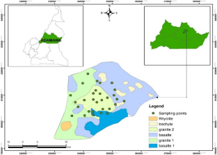
The radon-prone area of the Adamawa region in Cameroon is characterized by high natural radiation background resulting from the high concentrations of radium-226, thorium-232, and indoor radon. To produce a radon-risk map, radon measurements in soil were carried out in the city of Ngaoundere. The radon activity concentration in soil gas ranged from 256 to 166 kBq m−3 with a mean of 80 kBq m−3 and a standard deviation of 38 kBq m−3. The area is mostly classified as high risk (80%) according to the Swedish classification, and 20% as medium risk. A low-risk area was not observed. Granite-like geology sites were characterized by higher radon concentration. A ratio of about 295:1 was obtained for soil radon gas to indoor radon concentrations, with a positive correlation (R = 0.40), and a transfer factor of 3 per mil. These results demonstrate that in situ measurements of radon concentration in soil can provide accurate information on the level of indoor radon concentrations. Geostatistical and deterministic interpolation techniques have been used to obtain a radon map by comparing the suitability of ordinary kriging and inverse-distance-weighted (IDW) interpolation methods. It turned out that there is not much difference in the prediction errors of the two techniques (Root Mean Square Error = 34.4 for ordinary kriging and 34.3 for IDW). It is concluded that both methods give acceptable results. In situ measurements and geostatistical analysis allow assessment of expected indoor radon exposure in a given area at reduced costs and time required. However, for the investigated area, more research is needed to produce reliable radon-risk maps.
中文翻译:
通过测量土壤中氡气活度浓度绘制喀麦隆阿达马瓦地区氡气易发地区的地图
喀麦隆阿达马瓦地区氡气多发区的特点是,镭 226、钍 232 和室内氡浓度较高,自然辐射本底较高。为了绘制氡气风险图,在恩冈代雷市进行了土壤中的氡气测量。土壤气体中氡活度浓度范围为256至166 kBq m -3,平均值为80 kBq m -3,标准差为38 kBq m -3。根据瑞典的分类,该地区大部分被列为高风险(80%),20%为中风险。未观察到低风险区域。花岗岩类地质遗址的特点是氡浓度较高。土壤氡气与室内氡浓度之比约为 295:1,呈正相关(R = 0.40),传递因子为 3 per mil。这些结果表明,土壤中氡浓度的原位测量可以提供有关室内氡浓度水平的准确信息。通过比较普通克里格法和反距离加权 (IDW) 插值方法的适用性,使用地统计和确定性插值技术来获取氡气图。事实证明,两种技术的预测误差没有太大差异(普通克里金法的均方根误差 = 34.4,IDW 的均方根误差 = 34.3)。结论是两种方法都给出了可接受的结果。现场测量和地质统计分析可以以减少所需的成本和时间来评估给定区域的预期室内氡暴露。然而,对于所调查的区域,需要更多的研究来绘制可靠的氡气风险图。


 京公网安备 11010802027423号