Human Ecology ( IF 2.728 ) Pub Date : 2023-08-11 , DOI: 10.1007/s10745-023-00435-8 Alexei Aleinikov , Olga Lisitsyna
|
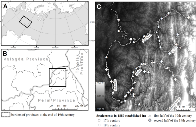
At the end of the nineteenth century, the northern territories of the Russian Plain and western piedmont of Northern Ural Mountains were under various land-use systems, including slash-and-burn (SAB) agriculture. Using archival materials for the years 1880–1910 as data sources, we analyse the the location and extent of SAB agriculture, it timing, and its impact on the landscapes at the turn of the nineteenth and twentieth centuries, and present a review of the historical and ethnographic literature. The study area is in the western piedmont of the Northern Ural Mountains, between the Kama and Pechora rivers in dark conifer dominated forests. The population is sparse (14 people per 100 km² in 1900) and settled along the rivers. In 1885 the practice of SAB agriculture was totally prohibited, but the unusually large crop harvest during the first years of the ban led people to risk breaking the law. Between the years 1885 and 1894 a total number of 175 SAB cases was recorded in the study area. The SAB sites were used only once before being abandoned. The recorded plots were usually cultivated by one family. They small (0.03 ha to 2.70 ha, with a median of 0.55 ha) and located within 7.5 km of the settlements. The practice SAB agriculture led to the formation of mosaics of multiple-aged pyrogenic forest associations near the settlements.
中文翻译:
19世纪末乌拉尔山脉北部刀耕火种农业档案分析
十九世纪末,俄罗斯平原北部地区和北乌拉尔山脉西部山麓处于各种土地利用制度下,包括刀耕火种(SAB)农业。我们以 1880 年至 1910 年的档案材料为数据来源,分析了 SAB 农业的位置和范围、时间及其对 19 世纪和 20 世纪之交景观的影响,并对历史进行了回顾。和民族志文献。研究区域位于北乌拉尔山脉西部山麓,卡马河和伯朝拉河之间,以深色针叶树为主的森林中。人口稀少(1900 年每 100 平方公里 14 人),沿河定居。1885年,SAB农业的做法被完全禁止,但禁令实施的头几年,农作物丰收异常丰收,导致人们冒着违法的风险。1885 年至 1894 年间,研究区域共记录了 175 起 SAB 病例。SAB 站点仅使用过一次就被废弃。记录下来的土地通常是由一个家庭耕种的。它们面积较小(0.03 公顷至 2.70 公顷,中位数为 0.55 公顷),距离定居点不到 7.5 公里。SAB 农业实践导致定居点附近形成了多种年龄的火成森林群落。面积中位数为 0.55 公顷),距离定居点 7.5 公里以内。SAB 农业实践导致定居点附近形成了多种年龄的火成森林群落。面积中位数为 0.55 公顷),距离定居点 7.5 公里以内。SAB 农业实践导致定居点附近形成了多种年龄的火成森林群落。


 京公网安备 11010802027423号