Arid Ecosystems Pub Date : 2023-08-12 , DOI: 10.1134/s2079096123030071 D. M. Lobacheva , E. N. Badyukova , R. R. Makshaev
|
Abstract
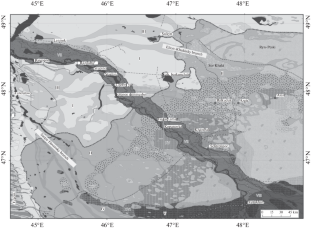
Many geological sections along the Lower Volga valley have been actively studied since the end of the 19th century. The results of field work showed that in all the studied Quaternary sections along the Lower Volga valley, alluvial deposits of the Khvalynian time (the end of the Late Pleistocene) are absent. Geomorphological mapping was carried out and many outcrops along the Volga valley and on the Baer knolls were studied. In the Khvalynian time, the Volga most likely did not flow in its present position. The purpose of this article was to determine the locations of the paleochannels of the Volga on the basis of geomorphological data, in particular, the spatial location and morphology of the Baer knolls. A large multi-branched delta (about 200–210-km wide), probably similar in size to the modern Lena delta, was located significantly to the north of the modern one. The delta existed in the form of a series of small and large branches; on the site of the modern Volga-Akhtuba there was probably a small central branch, the Sarpa branch was located in the west, and the Elton-Khaki branch was located in the east. At the beginning of the Holocene, the Sarpa and Khaksky branches began to die off, and most of the water began to rush along the central branch, forming the modern Volga-Akhtuba valley. The Sarpa-Davan channel system continued to be active in the period after the formation of the Baer knoll complex, that is, at the beginning of the Holocene during the Mangyshlak regression.
中文翻译:
根据地貌数据,赫瓦雷尼亚时代末伏尔加河古三角洲河道的位置
摘要
自 19 世纪末以来,人们对伏尔加河谷下游的许多地质剖面进行了积极的研究。野外工作的结果表明,在所有研究的伏尔加河下游河谷第四纪剖面中,都不存在赫瓦林期(晚更新世末期)的冲积沉积物。进行了地貌测绘,并对伏尔加河流域和贝尔山丘上的许多露头进行了研究。在赫瓦雷尼亚时期,伏尔加河很可能没有在现在的位置流动。本文的目的是根据地貌数据确定伏尔加河古河道的位置,特别是贝尔山丘的空间位置和形态。一个大型的多分支三角洲(约200-210公里宽),其大小可能与现代勒拿三角洲相似,位于现代的以北。三角洲以一系列大小分支的形式存在。在现代伏尔加-阿赫图巴河的遗址上可能有一个小的中央支流,萨尔帕支流位于西部,埃尔顿-卡其支流位于东部。全新世初期,萨尔帕支流和哈克斯支流开始枯死,大部分水开始沿着中央支流涌入,形成了现代的伏尔加-阿赫图巴河谷。萨帕-达万河道系统在贝尔山杂岩形成后的时期,即全新世初期的曼格什拉克海退期间继续活跃。西边是Sarpa分支,东边是Elton-Khaki分支。全新世初期,萨尔帕支流和哈克斯支流开始枯死,大部分水开始沿着中央支流涌入,形成了现代的伏尔加-阿赫图巴河谷。萨帕-达万河道系统在贝尔山杂岩形成后的时期,即全新世初期的曼格什拉克海退期间继续活跃。西边是Sarpa分支,东边是Elton-Khaki分支。全新世初期,萨尔帕支流和哈克斯支流开始枯死,大部分水开始沿着中央支流涌入,形成了现代的伏尔加-阿赫图巴河谷。萨帕-达万河道系统在贝尔山杂岩形成后的时期,即全新世初期的曼格什拉克海退期间继续活跃。


 京公网安备 11010802027423号