International Journal of Disaster Risk Science ( IF 4 ) Pub Date : 2023-08-24 , DOI: 10.1007/s13753-023-00505-x Zhiping Jiao , Zhida Xu , Rui Guo , Zhiwei Zhou , Liming Jiang
|
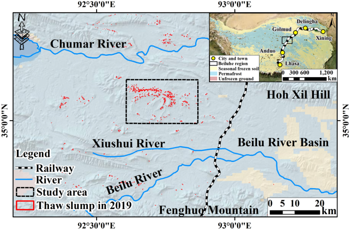
Permafrost degradation due to climate warming is severely reducing slope stability by increasing soil pore water pressure and decreasing shear strength. Retrogressive thaw slumps (RTSs) are among the most dynamic landforms in permafrost areas, which can result in the instability of landscape and ecosystem. However, the spatiotemporal characteristics of surface deformation of RTSs are still unclear, and the potentials of deformation properties in mapping large-scale RTSs need to be further assessed. In this study, we applied a multi-temporal Interferometric Synthetic Aperture Radar (MT-InSAR) method to map the spatiotemporal variations in surface deformation of RTSs in the Beiluhe region of the Tibetan Plateau by using 112 scenes of Sentinel-1 SAR data acquired from 2017 to 2021. The deformation rates of RTSs ranged from − 35 to 20 mm/year, and three typical motion stages were inferred by analyzing the deformation variation trend of the headwall of RTSs: stable, abrupt thaw, and linear subsidence. A total of 375 RTSs were identified in the Mati Hill region by combining InSAR-based deformation results with visual interpretation of optical remote sensing images. Among them, 76 RTSs were newly developed, and 26% more than the inventory derived from the optical images alone. This study demonstrated that the combination of InSAR-derived deformation with optical images has significant potential for detecting RTSs with high accuracy and efficiency at the regional scale.
中文翻译:
多时相InSAR探测倒退融雪的潜力:以青藏高原北麓河地区为例
气候变暖导致的永久冻土退化通过增加土壤孔隙水压力和降低剪切强度而严重降低边坡稳定性。退融塌陷(RTS)是永久冻土地区最具活力的地貌之一,可能导致景观和生态系统的不稳定。然而,RTS表面变形的时空特征仍不清楚,变形特性在绘制大规模RTS中的潜力需要进一步评估。本研究采用多时相干涉合成孔径雷达(MT-InSAR)方法,利用Sentinel-1 SAR数据的112个场景,绘制了青藏高原北麓河地区RTS地表形变的时空变化。 2017年至2021年。RTS的变形率范围为- 35至20毫米/年,通过分析RTS头壁变形变化趋势,推断出稳定、突变、线性沉降三个典型运动阶段。通过将基于 InSAR 的变形结果与光学遥感图像的视觉解释相结合,在马蒂山地区总共识别出了 375 个 RTS。其中,新开发的RTS有76个,比仅光学图像的库存多出26%。这项研究表明,InSAR 产生的变形与光学图像的结合对于在区域尺度上高精度和高效地检测 RTS 具有巨大的潜力。通过将基于 InSAR 的变形结果与光学遥感图像的视觉解释相结合,在马蒂山地区总共识别出了 375 个 RTS。其中,新开发的RTS有76个,比仅光学图像的库存多出26%。这项研究表明,InSAR 产生的变形与光学图像的结合对于在区域尺度上高精度和高效地检测 RTS 具有巨大的潜力。通过将基于 InSAR 的变形结果与光学遥感图像的视觉解释相结合,在马蒂山地区总共识别出了 375 个 RTS。其中,新开发的RTS有76个,比仅光学图像的库存多出26%。这项研究表明,InSAR 产生的变形与光学图像的结合对于在区域尺度上高精度和高效地检测 RTS 具有巨大的潜力。


 京公网安备 11010802027423号