International Journal of Disaster Risk Science ( IF 4 ) Pub Date : 2023-08-25 , DOI: 10.1007/s13753-023-00504-y Huarui Zhang , Huini Wang , Jun Zhang , Jing Luo , Guoan Yin
|
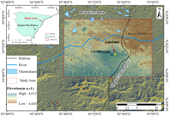
Thaw slumping is a periglacial process that occurs on slopes in cold environments, where the ground becomes unstable and the surface slides downhill due to saturation with water during thawing. In this study, GaoFen-1 remote sensing and fused multi-source feature data were used to automatically map thaw slumping landforms in the Beilu River Basin of the Qinghai–Tibet Plateau. The bi-directional cascade network structure was used to extract edges at different scales, where an individual layer was supervised by labeled edges at its specific scale, rather than directly applying the same supervision to all convolutional neural network outputs. Additionally, we conducted a 5-year multi-scale feature analysis of small baseline subset interferometric synthetic aperture radar deformation, normalized difference vegetation index, and slope, among other features. Our study analyzed the performance and accuracy of three methods based on edge object supervised learning and three preconfigured neural networks, ResNet101, VGG16, and ResNet152. Through verification using site surveys and multi-data fusion results, we obtained the best ResNet101 model score of intersection over union of 0.85 (overall accuracy of 84.59%).The value of intersection over union of the VGG and ResNet152 are 0.569 and 0.773, respectively. This work provides a new insight for the potential feasibility of applying the designed edge detection method to map diverse thaw slumping landforms in larger areas with high-resolution images.
中文翻译:
基于神经网络方法的解冻塌陷自动识别及解冻塌陷敏感性
解冻塌陷是一种发生在寒冷环境中斜坡上的冰缘过程,其中地面变得不稳定,并且由于解冻过程中水的饱和,地表向下滑动。本研究利用高分一号遥感数据融合多源特征数据,自动绘制青藏高原北麓河流域融雪塌陷地貌图。双向级联网络结构用于提取不同尺度的边缘,其中单个层由特定尺度的标记边缘进行监督,而不是直接对所有卷积神经网络输出应用相同的监督。此外,我们还对小基线子集干涉合成孔径雷达变形、归一化植被指数和坡度进行了为期 5 年的多尺度特征分析,除其他功能外。我们的研究分析了基于边缘对象监督学习和三个预配置神经网络 ResNet101、VGG16 和 ResNet152 的三种方法的性能和准确性。通过现场调查和多数据融合结果验证,我们得到了最好的ResNet101模型交并集得分为0.85(总体准确率84.59%)。VGG和ResNet152的交集并集值分别为0.569和0.773 。这项工作为应用设计的边缘检测方法以高分辨率图像绘制更大区域中的不同解冻塌陷地貌的潜在可行性提供了新的见解。通过现场调查和多数据融合结果验证,我们得到了最好的ResNet101模型交并集得分为0.85(总体准确率84.59%)。VGG和ResNet152的交集并集值分别为0.569和0.773 。这项工作为应用设计的边缘检测方法以高分辨率图像绘制更大区域中的不同解冻塌陷地貌的潜在可行性提供了新的见解。通过现场调查和多数据融合结果验证,我们得到了最好的ResNet101模型交并集得分为0.85(总体准确率84.59%)。VGG和ResNet152的交集并集值分别为0.569和0.773 。这项工作为应用设计的边缘检测方法以高分辨率图像绘制更大区域中的不同解冻塌陷地貌的潜在可行性提供了新的见解。


 京公网安备 11010802027423号