International Journal of Historical Archaeology Pub Date : 2023-10-02 , DOI: 10.1007/s10761-023-00712-8 Derwin Gregory
|
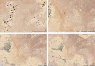
At the end of May 1942, the Axis Afrika Korps launched an assault on the Allied Eighth Army’s defences of the Gazala Line in Libya: the Gazala Line was located to the west of Tobruk, and stretched south into the Libyan desert. By the time the Axis attacked the Gazala Line, the Allies’ defences consisted of a series of boxes which were defended by the different brigades of the Eighth Army. In this article, the results of a survey of the field defences of the 151st Infantry Brigade using open access satellite imagery is discussed. This research will demonstrate that the 151st Infantry Brigade’s box was primarily designed to defend against a frontal assault. In addition, the survey demonstrates the value of open access satellite imagery for understanding Second World War desert battles.
中文翻译:
沙漠中的盒子:使用开放获取卫星图像绘制加扎拉防线上第 151 步兵旅的野战防御地图,1942 年
1942年5月下旬,轴心国非洲军团向盟军第八集团军在利比亚的加扎拉防线发起进攻:加扎拉防线位于托布鲁克以西,向南延伸至利比亚沙漠。当轴心国攻击加扎拉防线时,盟军的防御工事由一系列盒子组成,由第八集团军的不同旅负责防守。本文讨论了使用开放卫星图像对第 151 步兵旅野战防御进行调查的结果。这项研究将证明第 151 步兵旅的包厢主要是为了防御正面攻击而设计的。此外,该调查还证明了开放获取卫星图像对于了解第二次世界大战沙漠战斗的价值。


 京公网安备 11010802027423号