Biogeochemistry ( IF 4 ) Pub Date : 2023-10-10 , DOI: 10.1007/s10533-023-01084-1 Budiman Minasny , Diana Vigah Adetsu , Matt Aitkenhead , Rebekka R. E. Artz , Nikki Baggaley , Alexandra Barthelmes , Amélie Beucher , Jean Caron , Giulia Conchedda , John Connolly , Raphaël Deragon , Chris Evans , Kjetil Fadnes , Dian Fiantis , Zisis Gagkas , Louis Gilet , Alessandro Gimona , Stephan Glatzel , Mogens H. Greve , Wahaj Habib , Kristell Hergoualc’h , Cecilie Hermansen , Darren B. Kidd , Triven Koganti , Dianna Kopansky , David J. Large , Tuula Larmola , Allan Lilly , Haojie Liu , Matthew Marcus , Maarit Middleton , Keith Morrison , Rasmus Jes Petersen , Tristan Quaife , Line Rochefort , Rudiyanto , Linda Toca , Francesco N. Tubiello , Peter Lystbæk Weber , Simon Weldon , Wirastuti Widyatmanti , Jenny Williamson , Dominik Zak
|
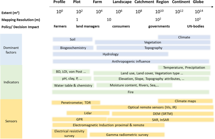
Peatlands cover only 3–4% of the Earth’s surface, but they store nearly 30% of global soil carbon stock. This significant carbon store is under threat as peatlands continue to be degraded at alarming rates around the world. It has prompted countries worldwide to establish regulations to conserve and reduce emissions from this carbon rich ecosystem. For example, the EU has implemented new rules that mandate sustainable management of peatlands, critical to reaching the goal of carbon neutrality by 2050. However, a lack of information on the extent and condition of peatlands has hindered the development of national policies and restoration efforts. This paper reviews the current state of knowledge on mapping and monitoring peatlands from field sites to the globe and identifies areas where further research is needed. It presents an overview of the different methodologies used to map peatlands in nine countries, which vary in definition of peat soil and peatland, mapping coverage, and mapping detail. Whereas mapping peatlands across the world with only one approach is hardly possible, the paper highlights the need for more consistent approaches within regions having comparable peatland types and climates to inform their protection and urgent restoration. The review further summarises various approaches used for monitoring peatland conditions and functions. These include monitoring at the plot scale for degree of humification and stoichiometric ratio, and proximal sensing such as gamma radiometrics and electromagnetic induction at the field to landscape scale for mapping peat thickness and identifying hotspots for greenhouse gas (GHG) emissions. Remote sensing techniques with passive and active sensors at regional to national scale can help in monitoring subsidence rate, water table, peat moisture, landslides, and GHG emissions. Although the use of water table depth as a proxy for interannual GHG emissions from peatlands has been well established, there is no single remote sensing method or data product yet that has been verified beyond local or regional scales. Broader land-use change and fire monitoring at a global scale may further assist national GHG inventory reporting. Monitoring of peatland conditions to evaluate the success of individual restoration schemes still requires field work to assess local proxies combined with remote sensing and modeling. Long-term monitoring is necessary to draw valid conclusions on revegetation outcomes and associated GHG emissions in rewetted peatlands, as their dynamics are not fully understood at the site level. Monitoring vegetation development and hydrology of restored peatlands is needed as a proxy to assess the return of water and changes in nutrient cycling and biodiversity.
中文翻译:
绘制和监测从全球到野外规模的泥炭地状况
泥炭地仅覆盖地球表面的 3-4%,但储存了全球近 30% 的土壤碳储量。随着世界各地泥炭地继续以惊人的速度退化,这一重要的碳储存正受到威胁。它促使世界各国制定法规,以保护和减少这个富含碳的生态系统的排放。例如,欧盟实施了新规则,要求对泥炭地进行可持续管理,这对于到 2050 年实现碳中和目标至关重要。然而,缺乏有关泥炭地范围和状况的信息阻碍了国家政策和恢复工作的制定。本文回顾了从实地到全球范围内绘制和监测泥炭地的知识现状,并确定了需要进一步研究的领域。它概述了九个国家用于绘制泥炭地地图的不同方法,这些方法在泥炭土和泥炭地的定义、绘图覆盖范围和绘图细节方面有所不同。尽管仅用一种方法来绘制世界各地的泥炭地地图几乎是不可能的,但本文强调,在具有可比泥炭地类型和气候的地区内需要采取更一致的方法,以便为泥炭地的保护和紧急恢复提供信息。该审查进一步总结了用于监测泥炭地状况和功能的各种方法。其中包括在地块尺度上监测腐殖化程度和化学计量比,以及在田间到景观尺度上进行近端传感(例如伽马辐射测量和电磁感应),以绘制泥炭厚度并识别温室气体(GHG)排放热点。在区域到国家范围内使用无源和有源传感器的遥感技术可以帮助监测沉降率、地下水位、泥炭湿度、山体滑坡和温室气体排放。尽管使用地下水位深度作为泥炭地年际温室气体排放量的替代指标已经很成熟,但还没有单一的遥感方法或数据产品在地方或区域尺度之外得到验证。全球范围内更广泛的土地利用变化和火灾监测可能会进一步协助国家温室气体清单报告。监测泥炭地状况以评估各个恢复计划的成功仍然需要结合遥感和建模进行实地工作以评估当地代理。有必要进行长期监测,以便就再湿泥炭地的植被恢复结果和相关温室气体排放得出有效结论,因为在现场层面尚未完全了解其动态。需要监测恢复泥炭地的植被发育和水文,作为评估水的回归以及养分循环和生物多样性变化的替代指标。


 京公网安备 11010802027423号