Our official English website, www.x-mol.net, welcomes your feedback! (Note: you will need to create a separate account there.)
Footprint of the Baltic Ice Stream: geomorphic evidence for shifting ice stream pathways
Boreas ( IF 2.2 ) Pub Date : 2023-10-13 , DOI: 10.1111/bor.12634 Sarah L. Greenwood 1 , Rachael S. Avery 1 , Richard Gyllencreutz 1 , Carl Regnéll 1 , Karol Tylmann 2
Boreas ( IF 2.2 ) Pub Date : 2023-10-13 , DOI: 10.1111/bor.12634 Sarah L. Greenwood 1 , Rachael S. Avery 1 , Richard Gyllencreutz 1 , Carl Regnéll 1 , Karol Tylmann 2
Affiliation
|
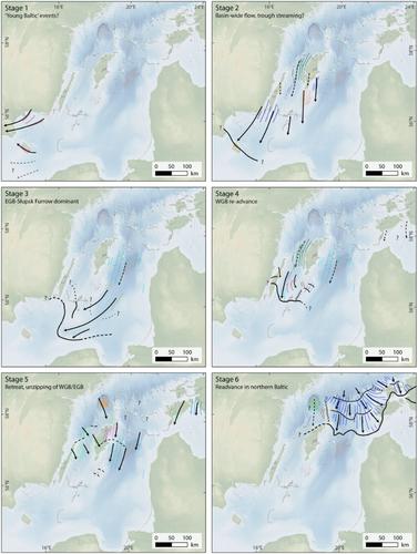
The Baltic Ice Stream, a large fast-flowing sector of the last Fennoscandian Ice Sheet that occupied the present-day Baltic Sea basin, was first conceptualized in the earliest days of glacial geological research in Scandinavia. Landform and sedimentological evidence from the terrestrial margins support the concept and numerical ice-sheet models demonstrate its existence and possible evolution. However, with evidence for the Baltic Ice Stream thus far limited to the terrestrial periphery, its true form, scale, function, and role in deglaciation have proven enigmatic. Here we present geomorphological evidence directly from the Baltic seabed that confirms the existence of and sheds light on the behaviour of the Baltic Ice Stream. Based on an extensive collection of high-, moderate- and low-resolution bathymetric terrain models covering a large proportion of the Baltic Sea floor, and complemented by LiDAR-data for the Baltic islands, we have identified and mapped >20 000 individual subglacial bedforms, meltwater landforms and grounding line landforms. We reconstruct a six-stage sequence of ice flow and retreat, finding that streaming was persistent in the Baltic but that pathways were variable in extent, timing and duration: different sectors of the Baltic exhibit asynchronous streaming and out-of-phase grounding line changes. During deglaciation, grounding line re-advances occurred in both the southwestern and the northern Baltic Proper, and, while abundant iceberg ploughmarks attest to calving as a significant ice loss mechanism, lobate margins suggest supply to the Baltic catchment was consistently high. Our reconstruction is limited by a fragmentary geomorphic record. Here we put forward a first hypothesis for how the Baltic Ice Stream evolved, and hope it stimulates new geomorphic, stratigraphical and core data collection to extend the landform record, provide insights into subglacial and grounding line processes, and constrain the chronology for Baltic Ice Stream flow and retreat.
中文翻译:

波罗的海冰流的足迹:冰流路径变化的地貌证据
波罗的海冰流是最后一个芬诺斯坎迪亚冰盖的一个快速流动的大型部分,占据了今天的波罗的海盆地,在斯堪的纳维亚半岛冰川地质研究的早期就首次被概念化。来自陆地边缘的地形和沉积学证据支持了这一概念,数值冰盖模型证明了其存在和可能的演化。然而,迄今为止,波罗的海冰流的证据仅限于陆地边缘,其真实形式、规模、功能和在冰消过程中的作用已被证明是个谜。在这里,我们直接提供来自波罗的海海底的地貌证据,证实了波罗的海冰流的存在并揭示了波罗的海冰流的行为。基于覆盖波罗的海海底大部分区域的广泛收集的高、中、低分辨率测深地形模型,并辅以波罗的海岛屿的 LiDAR 数据,我们已经识别并绘制了超过 20 000 个单独的冰下地床形态、融水地貌和接地线地貌。我们重建了冰流和退缩的六阶段序列,发现波罗的海的冰流持续存在,但路径在范围、时间和持续时间上各不相同:波罗的海的不同部分表现出异步流和异相接地线变化。在冰消期期间,波罗的海本土西南部和北部都发生了接地线重新推进,虽然大量的冰山犁痕证明崩解是一种重要的冰损失机制,但叶状边缘表明波罗的海流域的供应量始终很高。我们的重建受到不完整的地貌记录的限制。在这里,我们对波罗的海冰流如何演化提出了第一个假设,并希望它能够刺激新的地貌、地层和核心数据收集,以扩展地貌记录,提供对冰下和接地线过程的见解,并限制波罗的海冰流的年代学流与退。
更新日期:2023-10-13
中文翻译:
波罗的海冰流的足迹:冰流路径变化的地貌证据
波罗的海冰流是最后一个芬诺斯坎迪亚冰盖的一个快速流动的大型部分,占据了今天的波罗的海盆地,在斯堪的纳维亚半岛冰川地质研究的早期就首次被概念化。来自陆地边缘的地形和沉积学证据支持了这一概念,数值冰盖模型证明了其存在和可能的演化。然而,迄今为止,波罗的海冰流的证据仅限于陆地边缘,其真实形式、规模、功能和在冰消过程中的作用已被证明是个谜。在这里,我们直接提供来自波罗的海海底的地貌证据,证实了波罗的海冰流的存在并揭示了波罗的海冰流的行为。基于覆盖波罗的海海底大部分区域的广泛收集的高、中、低分辨率测深地形模型,并辅以波罗的海岛屿的 LiDAR 数据,我们已经识别并绘制了超过 20 000 个单独的冰下地床形态、融水地貌和接地线地貌。我们重建了冰流和退缩的六阶段序列,发现波罗的海的冰流持续存在,但路径在范围、时间和持续时间上各不相同:波罗的海的不同部分表现出异步流和异相接地线变化。在冰消期期间,波罗的海本土西南部和北部都发生了接地线重新推进,虽然大量的冰山犁痕证明崩解是一种重要的冰损失机制,但叶状边缘表明波罗的海流域的供应量始终很高。我们的重建受到不完整的地貌记录的限制。在这里,我们对波罗的海冰流如何演化提出了第一个假设,并希望它能够刺激新的地貌、地层和核心数据收集,以扩展地貌记录,提供对冰下和接地线过程的见解,并限制波罗的海冰流的年代学流与退。


 京公网安备 11010802027423号