International Journal of Disaster Risk Science ( IF 4 ) Pub Date : 2023-11-06 , DOI: 10.1007/s13753-023-00512-y Deniz Gerçek , İsmail Talih Güven
|
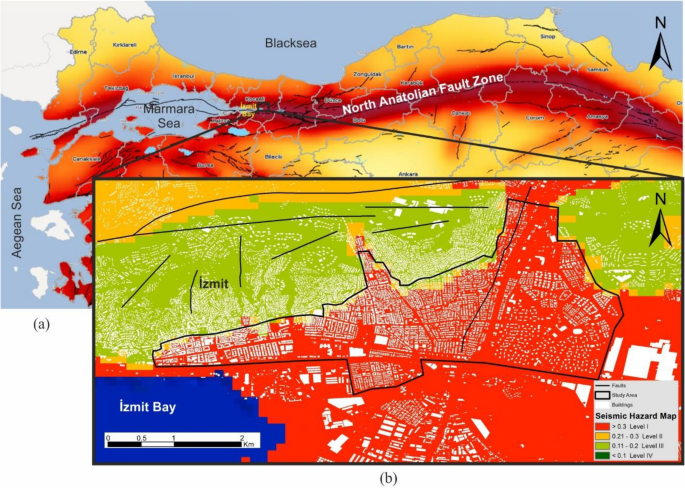
Vulnerability assessment and mapping play a crucial role in disaster risk reduction and planning for adaptation to a future earthquake. Turkey is one of the most at-risk countries for earthquake disasters worldwide. Therefore, it is imperative to develop effective earthquake vulnerability assessment and mapping at practically relevant scales. In this study, a holistic earthquake vulnerability index that addresses the multidimensional nature of earthquake vulnerability was constructed. With the aim of representing the vulnerability as a continuum across space, buildings were set as the smallest unit of analysis. The study area is in İzmit City of Turkey, with the exposed human and structural elements falling inside the most hazardous zone of seismicity. The index was represented by the building vulnerability, socioeconomic vulnerability, and vulnerability of the built environment. To minimize the subjectivity and uncertainty that the vulnerability indices based on expert knowledge are suffering from, an extension of the catastrophe progression method for the objective weighing of indicators was proposed. Earthquake vulnerability index and components were mapped, a local spatial autocorrelation metric was employed where the hotspot maps demarcated the earthquake vulnerability, and the study quantitatively revealed an estimate of people at risk. With its objectivity and straightforward implementation, the method can aid decision support for disaster risk reduction and emergency management.
中文翻译:
基于巨灾进展法的微尺度城市地震脆弱性评估与制图
脆弱性评估和绘图在减少灾害风险和规划未来地震适应方面发挥着至关重要的作用。土耳其是全球地震灾害风险最高的国家之一。因此,必须在实际相关尺度上开发有效的地震脆弱性评估和测绘。在这项研究中,构建了一个整体地震脆弱性指数,以解决地震脆弱性的多维性质。为了将脆弱性表示为跨空间的连续体,建筑物被设置为最小的分析单位。研究区域位于土耳其伊兹米特市,暴露的人体和结构元素位于地震活动最危险的区域内。该指数由建筑脆弱性、社会经济脆弱性和建筑环境脆弱性来表示。为了最大限度地减少基于专家知识的脆弱性指数所面临的主观性和不确定性,提出了一种对指标客观权重的突变级数方法的扩展。绘制了地震脆弱性指数和组成部分,在热点地图上采用了局部空间自相关度量来划分地震脆弱性,并且该研究定量地揭示了对处于危险中的人员的估计。该方法以其客观性和简单的实施方式,可以为减少灾害风险和应急管理提供决策支持。


 京公网安备 11010802027423号