Paddy and Water Environment ( IF 2.2 ) Pub Date : 2023-11-07 , DOI: 10.1007/s10333-023-00956-4 Daisuke Hizume , Toshinori Tabata , Kazuaki Hiramatsu , Masayoshi Harada , Akinori Ozaki
|
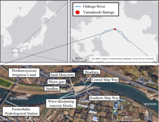
The Yamadazeki Barrage, located in Fukuoka Prefecture, Japan, is an oblique weir that was constructed at the middle reach of the Chikugo River in 1790 and is still operational. The weir was recognized as a World Heritage Irrigation Structures by the International Commission on Irrigation and Drainage. This study used hydraulic analyses of the Yamadazeki Barrage to understand its function. Two-dimensional shallow water equations were utilized for the hydraulic analyses, and the calculated velocity distribution under ordinary flow conditions (approximately 40 m3/s) showed good agreement with the measured data. In addition, the bedload transport rate was calculated from the water velocity and depth distributions using the Ashida-Michiue formula to simulate riverbed variations. The results suggested that there was slight erosion and deposition in the vicinity of the weir under ordinary flow conditions. In contrast, under flood flows of approximately 3500 m3/s, riverbed variations occurred in most of the calculation area, with extensive erosion and deposition of more than 2.0 m over 24 h. To reevaluate the structural functions of the Yamadazeki Barrage, elimination scenarios of both the Southern Ship Way and the Sand Sluiceway, which are considered important sand removers, were determined and analyzed. These scenarios revealed that the flow became unstable, and riverbed variations were significant. Therefore, these structural elements stabilized the water flow and maintained a safe and reliable water withdrawal. Additionally, the relevance of the weir structures, which was carefully calculated and designed to match the river flow rate and water level, was evaluated numerically.
中文翻译:
使用二维浅水方程进行水力分析,对日本筑后河 Yamadazeki 拦河坝进行功能评估
山田泽拦河坝位于日本福冈县,是一座斜堰,于1790年在筑后川中游修建,至今仍在运行。该堰被国际灌溉排水委员会认定为世界灌溉结构遗产。本研究利用山田泽拦河坝的水力分析来了解其功能。采用二维浅水方程进行水力分析,计算得到的普通水流条件(约40 m 3 /s)下的速度分布与实测数据吻合良好。此外,还使用 Ashida-Michiue 公式根据水流速度和深度分布计算了底泥输送率,以模拟河床变化。结果表明,在正常水流条件下,堰附近存在轻微的冲刷和沉积。相比之下,在约3500 m 3 /s的洪水流量下,大部分计算区域的河床都发生了变化,24 h内大面积冲淤超过2.0 m。为了重新评估山田泽拦河坝的结构功能,确定并分析了被认为是重要除沙设施的南航道和排砂闸道的消除情景。这些情况表明流量变得不稳定,河床变化显着。因此,这些结构元件稳定了水流并保持安全可靠的取水。此外,还对经过仔细计算和设计以匹配河流流速和水位的堰结构的相关性进行了数值评估。


 京公网安备 11010802027423号