GPS Solutions ( IF 4.9 ) Pub Date : 2023-11-25 , DOI: 10.1007/s10291-023-01575-6 Jinsheng Tu , Xiufeng He , Xiaolei Wang , Minfeng Song , Guoqing Chen , Zhixiang Yang
|
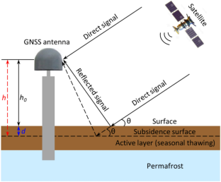
The freeze–thaw cycle of the active layer in permafrost areas can cause obvious surface deformation. Global navigation satellite system interferometric reflectometry (GNSS-IR) technology has been successfully applied to monitor surface deformation in permafrost areas. However, the monitoring capability of the BeiDou navigation satellite system (BDS) signals has not been investigated. In this study, we selected the GNSS site SG27 in Utqiaġvik (Barrow), Alaska, to process the BDS signal-to-noise ratio (SNR) observations from 2018 to 2022, and the continuous surface reflector height was extracted. Combined with the 2 m air temperature and snow cover provided by the nearby Barrow Observatory (BRW), the start and end dates of the annual snow-free thaw season were determined, and surface subsidence during this period was analyzed. Our results show that BDS-IR effectively monitors the surface subsidence trend. Compared with the subsidence trend value simulated by the thawing index, the S2I and S6I SNR retrieval results are strongly correlated with it, especially in 2019, with a correlation coefficient (R) higher than 0.90. The R of the S7I results is low, which is caused by the small number of available satellites in this frequency band in the study area. To further verify the reliability of the BDS-IR, we compared it with the GPS S1C SNR retrieval results and found good consistency. This study fills the gap in the application of BDS-IR in permafrost surface subsidence monitoring.
中文翻译:
利用北斗干涉反射仪监测永久冻土层表面沉降
多年冻土区活动层的冻融循环会引起明显的地表变形。全球导航卫星系统干涉反射技术(GNSS-IR)已成功应用于多年冻土地区地表形变监测。然而,北斗卫星导航系统(BDS)信号的监测能力尚未得到研究。在本研究中,我们选择阿拉斯加乌特恰维克(巴罗)的GNSS站点SG27来处理2018年至2022年的BDS信噪比(SNR)观测结果,并提取连续的表面反射体高度。结合附近巴罗天文台(BRW)提供的2 m气温和积雪,确定了每年无雪融雪季节的起止日期,并分析了该期间的地表沉降情况。结果表明,北斗红外可以有效监测地表沉降趋势。与解冻指数模拟的沉降趋势值相比,S2I和S6I信噪比反演结果与其具有较强的相关性,尤其是2019年,相关系数(R)高于0.90。S7I结果的R较低,这是由于研究区该频段可用卫星数量较少造成的。为了进一步验证BDS-IR的可靠性,我们将其与GPS S1C信噪比反演结果进行了对比,发现具有良好的一致性。该研究填补了北斗红外在多年冻土地表沉降监测中应用的空白。


 京公网安备 11010802027423号