Arid Ecosystems Pub Date : 2023-11-25 , DOI: 10.1134/s2079096123040108 N. M. Novikova , Zh. V. Kuz’mina , N. K. Mamutov
|
Abstract
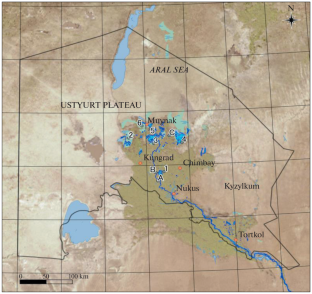
This paper discusses the dynamics of ecosystems and their components in connection with the development of the Aral Sea environmental crisis. The theoretical basis of this study was the idea that the vegetation dynamics under the conditions of deltaic landscape desertification represents an anthropogenically-induced natural hologenetic process involving the replacement of vegetation typical for hydromorphic floodplain and reed-bed biotopes with vegetation of semihydromorphic meadow and solonchak biotopes resulting in the formation of zonal vegetation typical for automorphic biotopes. These endo–ecogenetic successions are determined by the directed reduction in moisture supply in biotopes and accompanying salinization and evolution of soils. The changes occur in both successional and catastrophic ways. In the northern, undeveloped part of the Amu Darya River delta, the reduction of the sea water surface and a sharp drop in water reserves resulted by the 1990s in the formation of environmental conditions typical for desert landscapes: the climate parameters and their regime became close to desert ones, while the groundwater level fell to a depth of 5–10 m, thus, making groundwaters inaccessible to plant roots. Reconstruction of the reservoir system and flooding of former marine bays contribute to the formation of hydromorphic conditions on local sites. Geobotanical studies commenced in the Amu Darya River delta in 1979 and involved route surveys and surveys of topo–ecological profiles passing through the main deltaic relief elements (levees, their slopes, and interchannel depressions) were repeated in the monitoring mode in 1985, 1993, and 1999. Route surveys performed in 2017 showed that the current vegetation dynamics stage involves the formation of desert plant communities. Black saxaul (Haloxylon aphyllum (Minkw.) Iljin) first discovered in the Muynak district in 1993 is actively spreading in the most part of the undeveloped delta that has turned into a wasteland after the extinction of common reed (Phragmites australis (Cav.) Trin. ex Steud.) communities in the 1970s–1980s. The desert species Krasheninnikovia ceratoides (L.) Gueldenst. that has invaded degrading tugai and sparse arborescent saltwort (Salsola dendroides Pall.) monocoenoses on takyr solonchak soils around the same years formed extensive thickets north of the city of Kungrad. Observations on topo–ecological profiles made it possible to examine individual changes and stages in more detail. On the right bank of the Akdar’ya River that feeds the Mezhdurechenskoe Reservoir, on the Porlytau topo–ecological profile located 3 km southwest of the upland of the same name, over the course of the 40-year observation period, the river washed away a section of the near-channel floodplain and levee 500 m wide and was incised 9 m into the ground following a drop in the erosion base level (i.e., water level in the eastern part of the Greater Sea) by 26 m. Plant communities successions develop slowly. They follow the path of successional replacement of an arboreal Рoplar tugai (Populus ariana + Populus pruinosa + Elaeagnus angustifolia–Mixteherbosa with a shrubby tugai with Tamarix ramosissima Ledeb. ending in a nearby section of the interchannel depression with a catastrophic change: the death of the Halostachys belangeriana (Moq.) Botsch. community. This community was formed in 1985 as a result of soil salinization in the area previously occupied by reeds. In 2017, a slow surface desalination process that began in 1993 due to the illuviation of salts from upper (0–10 cm) horizons to lower ones continued in the soil at all survey points on the profile. For the first time, the desert shrub species Krasheninnikovia ceratoides (L.) Gueldenst. was recorded on the tugai fringe in 2017; over time, this species will probably colonize this entire site characterized by the profile. In the northeastern part of the delta, on the Kunyadarya topo–ecological profile that begins on the right bank of the dry channel of the same name and descends in the southeastern direction to the coastal plain, a degrading Populus diversifolia-Halimodendron halodendron tugai on the levee is being replaced by a tamarisk tugai, which is indicated by the species composition of the community: Populus diversifolia-Tamarix laxa + Halimodendron halodendron + T. ramosissima–Atriplex tatarica. In 2017, black saxaul was first recorded in a community formed by tall well-developed tamarisks and succulent saltworts located further along the profile on the levee slope. The profile enters a coastal solonchak plain with a Halostachys belangeriana–Climacoptera aralensis community. The salinity profiles of soils under all plant communities have a similar feature: the salt content reaches its maximum in the upper part of the profile (0–10 cm); then it sharply decreases in the 10–20-cm horizon and does not change down the profile to a depth of 50 cm. Salinity profiles of soils on two sites occupied by the tugai have the maximum similarity. The uppermost (0–5 cm) horizon is less saline or somewhat washed out from salts compared to the deeper (5–10 cm) horizon featuring the maximum salt content. In the Halostachys belangeriana community, the salt content reaches its maximum (8.28%) in the surface soil horizon (0–5 cm), then it sharply decreases to 2% in the 10–20-cm horizon, and further decreases down the profile to almost 1%. The salinity profile under tamarisk communities differs from other profiles: overall, it is slightly saline and has two maxima: mild surface salinity (0.5% at a depth of 0–5 cm) and medium salinity (0.8%) at a depth of 20–30 cm. Salinity profiles of soils on the Kunyadarya topo–ecological profile indicate progressive salinization of soils with a clearly pronounced surface-accumulative profile under the impact of pulsating secondary hydromorphism in this area provoked by water flows from the Dzhiltyrbas Bay towards the sea that occur on a periodic basis. In 2017, a newly-formed young woody tugai on the bank of an irrigation canal crossing the degrading Yerkin tugai was described. It differs from the degrading tugai forests described earlier in its full-fledged structure (it has three storeys) and in richness of its plant species composition (12 species). Two liana species are present, and renewal of predominant tree species occurs. The soil under the young tugai is alluvial–meadow–tugai (hydromorphic); it is slightly saline (0.36%) only in the near-surface horizon (0–5 cm). Comparison of data collected on topo–ecological profiles with data collected in the course of previous observations made it possible for the first time to conclude that the changes of plant associations in woody tugai communities in the undeveloped part of the delta under the desertification conditions occurs mainly in a successional way; while herbaceous and shrub communities, especially halophilic ones and their variants, are characterized by predominantly catastrophic changes. After their death, long-lasting wastelands are formed on lands previously occupied by such communities where favorable conditions for the introduction of species with different ecology are created. In local hydromorphic conditions with floodplain regimes, the formation and existence of tugai plant communities is possible. The practical significance of the results is that they characterize the diversity of environmental conditions and processes currently occurring in the vegetation and landscapes in the undeveloped part of the Amu Darya River delta and can be applied in resource use and biodiversity conservation practices.
中文翻译:
咸海危机条件下阿姆河三角洲荒漠化与植被动态
摘要
本文讨论了与咸海环境危机的发展有关的生态系统及其组成部分的动态。本研究的理论基础是这样的观点:三角洲景观荒漠化条件下的植被动态代表了人为引起的自然全息过程,涉及水化漫滩和芦苇床生境典型植被被半水化草甸和索伦恰克生境植被取代导致形成自守群落生境典型的带状植被。这些内生生态演替是由生境中水分供应的直接减少以及伴随的土壤盐化和进化决定的。这些变化以连续的和灾难性的方式发生。在阿姆河三角洲北部未开发的地区,20世纪90年代海水面减少和水储量急剧下降,形成了典型的沙漠景观环境条件:气候参数及其状况变得接近沙漠地区,地下水位下降到5~10m,植物根系无法接触到地下水。水库系统的重建和前海湾的洪水促进了当地水貌条件的形成。阿姆河三角洲的地球植物学研究于1979年开始,涉及路线调查和通过主要三角洲地形要素(堤坝、斜坡和河道间洼地)的地形生态剖面调查,并于1985年、1993年以监测模式重复进行。和1999年。2017年进行的路线调查表明,当前植被动态阶段涉及荒漠植物群落的形成。黑梭梭 ( Haloxylon aphyllum (Minkw.) Iljin) 于 1993 年在 Muynak 地区首次发现,目前在普通芦苇 ( Phragmites australis (Cav.) Trin)灭绝后已变成荒地的未开发三角洲大部分地区积极蔓延。. ex Steud.) 20 世纪 70 年代至 80 年代的社区。沙漠物种Krasheninnikova ceratoides (L.) Gueldenst。已经侵入了退化的土盖和稀疏的树状盐草(Salsola dendroides)大约在同一年,takyr sonchak 土壤上的单群落在昆格勒市以北形成了大片灌木丛。对地形生态概况的观察使得更详细地检查个体变化和阶段成为可能。在为 Mezhdurechenskoe 水库供水的 Akdar'ya 河右岸,位于同名高地西南 3 公里处的 Polytau 地形生态剖面上,在 40 年的观测期间,河流冲走了近河道漫滩和堤坝的一段,宽 500 m,在侵蚀基准面(即大海东部水位)下降 26 m 后,被切入地面 9 m。植物群落演替发展缓慢。他们沿着用灌木状的柽柳 ( Tamarix ramosissima Ledeb) 连续取代树栖 Рoplar tugai ( Populus ariana + Populus pruinosa + Elaeagnus angustifolia – Mixteherbosa ) 的道路。最终在河道间凹陷的附近部分发生了灾难性的变化:Halostachys belangeriana (Moq.) Botsch. 群落。该群落于 1985 年形成,是由于之前芦苇占据的地区土壤盐碱化。2017 年,由于上游盐分的浸蚀,1993 年开始的缓慢的地表海水淡化过程(0–10 cm) 地平线到较低地平线在剖面上的所有调查点的土壤中持续存在。2017 年,首次在 tugai 边缘记录到沙漠灌木物种Krasheninnikovia ceratoides (L.) Gueldenst.;随着时间的推移, 该物种可能会定居在以剖面为特征的整个地点。在三角洲的东北部,Kunyadarya 地形生态剖面上,该剖面从同名干河道的右岸开始,沿东南方向下降到在沿海平原,堤坝上正在退化的胡杨-Halimodendron halodendron tugai正在被柽柳tugai取代,这从群落的物种组成可以看出: Populus diversifolia-Tamarix laxa + Halimodendron halodendron + T. ramosissima – Atriplex tatarica。2017年,黑梭梭首次被记录在一个由高大发育良好的柽柳和多汁咸草组成的群落中,该群落位于堤坡轮廓的更远处。剖面进入沿海索伦恰克平原,其中有Halostachys belangeriana – Climacoptera aralensis 社区。各植物群落土壤盐分剖面具有相似的特征:盐分含量在剖面上部(0~10 cm)达到最大;然后在 10-20 厘米地平线处急剧减小,并且在剖面深度至 50 厘米处也没有变化。土盖人占据的两个地点的土壤盐度分布具有最大的相似性。与含盐量最高的较深层(5-10 厘米)相比,最上面(0-5 厘米)层的盐分较少,或者有些被盐冲刷掉。在Halostachys belangeriana中群落中,盐分含量在表土层(0-5 cm)达到最大(8.28%),然后在10-20 cm层急剧下降至2%,并进一步下降至近1% 。柽柳群落下的盐度剖面与其他剖面不同:总体而言,它是微盐的,并且有两个最大值:轻度表面盐度(0-5cm深度处为0.5%)和中等盐度(0.8%)在20-20cm深度处。 30 厘米。Kunyadarya 地形生态剖面上的土壤盐度剖面表明,在该地区周期性发生的从 Dzhiltyrbas 湾流向大海的水流引起的脉动次生水态作用的影响下,土壤逐渐盐化,具有明显明显的表面累积剖面。基础。2017年,一条新形成的年轻木本图盖出现在一条灌溉渠的岸边,该运河穿过正在退化的耶金图盖。它与前面描述的退化的土盖森林的不同之处在于其成熟的结构(三层)和植物物种组成的丰富性(12 种)。存在两种藤本植物,并且主要树种发生更新。幼土盖下的土壤是冲积土-草甸土-土盖(水成土);仅在近地表地平线(0-5 厘米)处具有微咸度(0.36%)。将地形生态剖面数据与前期观测数据进行比较,首次得出荒漠化条件下三角洲未开发地区木本tugai群落植物群落变化主要发生的结论以连续的方式;而草本和灌木群落,特别是嗜盐群落及其变种,则主要以灾难性变化为特征。它们死亡后,在这些群落以前占据的土地上形成了持久的荒地,为引入不同生态的物种创造了有利条件。在具有洪泛区的当地水貌条件下,土盖植物群落的形成和存在是可能的。研究结果的实际意义在于,它们描述了阿姆河三角洲未开发地区植被和景观中当前发生的环境条件和过程的多样性,可应用于资源利用和生物多样性保护实践。


 京公网安备 11010802027423号