Physics of the Earth and Planetary Interiors ( IF 2.3 ) Pub Date : 2023-11-26 , DOI: 10.1016/j.pepi.2023.107124 Mohsen Azqandi , Mohammad Reza Abbassi , Meysam Mahmoodabadi , Esmaeil Shabanian , Ahmad Sadidkhouy
|
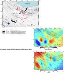
The collision between Arabia and Eurasia has had a significant impact on the Iranian plateau, making it a prime location for investigating crustal deformation. The Neotethys Ocean closure and subsequent collision during the Cenozoic era led to extensive deformation in the northern part of the Iranian plateau, in particular development of the Alborz mountain range. In this study, we aim to determine crustal thickness and azimuthal anisotropic parameters in order to gain insights into the patterns of crustal deformation in the region. Using the H-κ-c method (Li et al., 2019), we conducted an investigation into the impact of seismic anisotropy on the estimation of the crustal thickness (H) and Vp/Vs ratio (κ) at 26 seismic stations. Our analysis unveiled significant variations in Moho depth across the studied region. The collisional zones featured a deeper Moho depth when compared to Central Iran. In particular, the Central Iran region demonstrated a relatively thinner crust, characterized by an average Moho depth of 43 km, while the Sanandaj-Sirjan zone showcased a thicker crust, boasting a Moho depth of 59 km. The Alborz mountain ranges demonstrated an average Moho depth of 50 km. Notably, the Central Iran stations exhibited elevated κ values, potentially attributable to fluid contents and thick sedimentary cover. To characterize the anisotropic properties of the crust, we employed curve fitting techniques on the sinusoidal moveouts of the Ps-converted phases originating from the Moho and major intracrustal interfaces. Our analysis identified intracrustal discontinuities at seven stations, indicating the presence of two distinct anisotropic crustal layers. These anisotropic layers displayed maximum delay times of up to 0.6 s. Furthermore, our examination of crustal and mantle anisotropy patterns revealed that the deformation observed in the region cannot be solely attributed to a vertically coherent regime.
中文翻译:
伊朗从扎格罗斯到厄尔布尔士的地壳变形和厚度变化:H-κ-c方法的新见解
阿拉伯与欧亚大陆的碰撞对伊朗高原产生了重大影响,使其成为研究地壳变形的黄金地点。新生代时期的新特提斯洋闭合和随后的碰撞导致伊朗高原北部发生广泛变形,特别是厄尔布尔士山脉的发育。在这项研究中,我们的目标是确定地壳厚度和方位各向异性参数,以便深入了解该地区地壳变形的模式。利用H- κ -c方法(Li等,2019),研究了地震各向异性对26个地震台站地壳厚度(H)和Vp /Vs比值(κ)估计的影响。我们的分析揭示了整个研究区域莫霍面深度的显着变化。与伊朗中部相比,碰撞区的莫霍面深度更深。特别是伊朗中部地区地壳相对较薄,平均莫霍面深度为43公里,而萨南达季-锡尔詹地区地壳较厚,莫霍面深度为59公里。厄尔布尔士山脉的平均莫霍面深度为 50 公里。值得注意的是,伊朗中部站表现出较高的κ值,这可能归因于流体含量和厚的沉积覆盖层。为了表征地壳的各向异性特性,我们对源自莫霍面和主要地壳内界面的Ps转换相的正弦时移采用了曲线拟合技术。我们的分析确定了七个站点的地壳内不连续性,表明存在两个不同的各向异性地壳层。这些各向异性层的最大延迟时间高达 0.6 秒。此外,我们对地壳和地幔各向异性模式的检查表明,在该区域观察到的变形不能仅仅归因于垂直相干机制。


 京公网安备 11010802027423号