Inland Water Biology ( IF 0.9 ) Pub Date : 2023-12-19 , DOI: 10.1134/s1995082923060123 Esengül Köse
|
Abstract
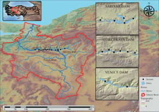
The present study aimed to assess the status of successive dams on surface water quality, especially in reducing organic pollution levels, and their effects on the ecological life were investigated. Water samples were collected seasonally from three dam’s monitoring stations. Temperature, pH, dissolved oxygen, electrical conductivity, turbidity, ammonium nitrogen, nitrite nitrogen, nitrate-nitrogen, sulfate, total phosphorus, chemical oxygen demand, biochemical oxygen demand and total hardness parameters were measured in surface waters. The Geographic Information System (GIS) was used to produce thematic maps of the investigated parameters. Stations used as point feature layers were mapped using quantitative labeling via symbology. The results were compared with Turkish Regulation, 2015 and EC Directive on the quality of fresh waters needing protection or improvement to support fish life (2006) guidelines. According to the results of the analysis, Dams that are located one after the other contribute to the partial cleaning of the water by resting. Sarıyar, Gökçekaya, and Yenice Dams were built on the Sakarya River, which is one of Türkiye’s biggest and most significant river systems, for electric supply and utility of water for irrigation and fishery activities. Gökçekaya Dam Lake was built between Sarıyar Dam and Yenice Dam, which are situated in the same line of Sakarya River. Gökçekaya and Yenice Dams are fed by Sarıyar Dam Lake and do not receive fresh water. The fact that the three dams are established one after the other aids in the water’s resting and the aids in removing the suspended solids/suspended load. But, this research show that domestic, industrial, agricultural wastes carried by the branches of the rivers caused algal blooms in Dam lakes, especially which are not fed with fresh water. Due to organic pollution the decrease in dissolved oxygen, especially from time to time, negatively affects the ecological life in the lakes.
中文翻译:
基于 GIS 的研究,调查连续水坝对地表水质的生态影响:土耳其萨卡里亚盆地回顾
摘要
本研究旨在评估历代水坝对地表水质量的影响,特别是在降低有机污染水平方面的影响,并调查它们对生态生活的影响。从三个大坝的监测站季节性采集水样。测量地表水的温度、pH、溶解氧、电导率、浊度、铵态氮、亚硝态氮、硝态氮、硫酸盐、总磷、化学需氧量、生化需氧量和总硬度等参数。地理信息系统(GIS)用于生成所研究参数的专题图。用作点要素图层的站点通过符号系统使用定量标记进行映射。将结果与土耳其法规 2015 和欧盟关于需要保护或改善以支持鱼类生命的淡水质量的指令 (2006) 指南进行了比较。根据分析结果,一个接一个的水坝通过休息有助于部分净化水。 Sarıyar、Gökçekaya 和 Yenice 大坝建在萨卡里亚河上,萨卡里亚河是土耳其最大、最重要的河流系统之一,用于电力供应以及灌溉和渔业活动的用水。 Gökçekaya 大坝湖建在 Sarıyar 大坝和 Yenice 大坝之间,这两个大坝位于萨卡里亚河的同一线上。 Gökçekaya 和 Yenice 水坝由 Sarıyar 大坝湖供水,不接收淡水。事实上,三座大坝相继建立,有助于水的静止,并有助于去除悬浮固体/悬浮物。但是,这项研究表明,河流支流携带的生活、工业和农业废物导致了水坝湖中的藻类大量繁殖,特别是那些没有淡水的水坝湖。由于有机污染,溶解氧的减少,尤其是时不时的减少,对湖泊的生态生活产生了负面影响。


 京公网安备 11010802027423号