Geography and Natural Resources Pub Date : 2023-12-21 , DOI: 10.1134/s1875372823030010 V. R. Alekseev , O. M. Makarieva , A. N. Shikhov , N. V. Nesterova , A. A. Zemlyanskova , A. A. Ostashov
|
Abstract
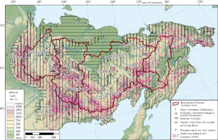
This article describes the compilation procedure and contents of the Atlas of giant taryn aufeis, a specific form of glaciation in the northeastern part of the Eurasian continent resulting from the freezing of groundwater that has come to the surface. The Atlas consists of two parts: analytical with illustrations and cartographic. Part I presents an overview of the extensive history of research on aufeis and the results of the digitization of small-scale maps that describe the dependence of aufeis fields on permafrost–hydrogeological, hydroclimatic, geomorphological, and geotectonic conditions. A special section of the Atlas is devoted to hazardous glacial and permafrost–geological phenomena that affect the engineering development of the territory. The results of the study indicate that about 5% of the territory of northeastern Russia can be described as an aufeis-prone zone. Part II of the Atlas contains over 100 maps of the distribution of taryn aufeis along the basins of major rivers of northeastern Russia (Yana, Indigirka, Kolyma, Anadyr, and Penzhina). The maps indicate the current positions and sizes of about 7000 aufeis fields as identified from Landsat and Sentinel-2 satellite images; they are compared with the Cadastre of Aufeis by A.S. Simakov and Z.G. Shil’nikovskaya (1958). An analysis of the data has revealed ambiguous trends of changes in aufeis fields. On the one hand, their number increased by the 21st century, but, on the other hand, the total preablation aufeis area decreased. Information on retrospective and current locations of aufeis fields is presented in the form of a digital database for large rivers of northeastern Russia. Most of the data collected in the Atlas requires detailed analysis.
中文翻译:
俄罗斯东北部的巨型 Taryn Aufeis
摘要
本文介绍了巨型塔林奥菲斯图集的编制过程和内容,巨型塔林奥菲斯是欧亚大陆东北部的一种特殊形式的冰川作用,是由于上升到地表的地下水冻结而产生的。该地图集由两部分组成:带有插图的分析部分和制图部分。第一部分概述了奥菲斯研究的广泛历史以及小比例尺地图的数字化结果,这些地图描述了奥菲斯场对永久冻土的依赖性——水文地质、水文气候、地貌和大地构造条件。该地图集的一个特殊部分专门讨论影响该地区工程发展的危险冰川和永久冻土地质现象。研究结果表明,俄罗斯东北部约5%的领土可称为奥菲斯多发区。该地图集的第二部分包含 100 多张塔伦奥菲斯沿俄罗斯东北部主要河流(亚纳河、印迪吉尔卡河、科雷马河、阿纳德尔河和彭日纳河)流域分布的地图。这些地图显示了从 Landsat 和 Sentinel-2 卫星图像中识别出的约 7000 个 aufeis 区域的当前位置和大小;将它们与 AS Simakov 和 ZG Shil'nikovskaya (1958) 的 Aufeis 地籍进行了比较。对数据的分析揭示了奥菲斯领域变化的模糊趋势。一方面,到了 21 世纪,它们的数量有所增加,但另一方面,消融前的总面积却减少了。有关奥菲斯油田的回顾和当前位置的信息以俄罗斯东北部大河流数字数据库的形式呈现。图集中收集的大部分数据都需要详细分析。


 京公网安备 11010802027423号