Journal of Coastal Conservation ( IF 2.1 ) Pub Date : 2023-12-29 , DOI: 10.1007/s11852-023-01016-z Kamrul Islam , Sajib Sarker , Golam Morsad , Mohd. Fardeen Khan , Arif Chowdhury , Syed Labib Ul Islam
|
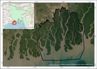
Land use change is a global issue, and different regions of Bangladesh are experiencing land use changes at different scales. The Sundarbans is one of the largest mangrove forests that provide resources to the local communities, act as a sink for CO2, and protect the coastal zone from natural disasters. Sundarbans is also being affected by land use change and deteriorating rapidly, posing a threat to mangroves and wildlife. This is mainly driven by the unplanned expansion of open land, deforestation, and filling up the water bodies. Evaluating the shoreline food web and the interaction of water and land necessitates quantitatively assessing shoreline movement patterns over time. This study aimed to understand the spatial–temporal changes in shoreline and vegetation from 1981 to 2021 considering the mangrove cover along the Sundarbans in Bangladesh. To fulfill the objectives, the Digital Shoreline Analysis System was used to measure the shoreline change, and the vegetation changes were assessed by using the Normalized Difference Vegetation Index (NDVI) using Landsat satellite data. The analysis of NDVI revealed that the mangrove stress level is increasing rapidly. In the last 20 years, the high-level vegetation has decreased by 5.01%, the moderate level by 9.61% & the low level by 6.99%. Moreover, the shoreline change analysis found that from 1980 to 1990 the erosion was 143.95 sq. km and the accretion was 110.9 sq. km. The findings of this study may help policymakers make informed decisions, and improve their plans for the sustainable development of the region.
中文翻译:
海岸线和植被的时空变化:对孟加拉国孙德尔本斯地区红树林覆盖的影响
土地利用变化是一个全球性问题,孟加拉国不同地区正在经历不同规模的土地利用变化。孙德尔本斯是最大的红树林之一,为当地社区提供资源,充当 CO 2汇,并保护沿海地区免受自然灾害的影响。孙德尔本斯也受到土地利用变化的影响并迅速恶化,对红树林和野生动物构成威胁。这主要是由于无计划的开放土地扩张、森林砍伐和水体填满造成的。评估海岸线食物网以及水和土地的相互作用需要定量评估海岸线随时间的运动模式。本研究旨在了解 1981 年至 2021 年海岸线和植被的时空变化,考虑孟加拉国孙德尔本斯沿线的红树林覆盖。为了实现这些目标,数字海岸线分析系统被用来测量海岸线变化,并利用陆地卫星数据的归一化植被指数(NDVI)来评估植被变化。NDVI分析显示,红树林的胁迫水平正在迅速增加。近20年来,高层植被减少了5.01%,中度植被减少了9.61%,低度植被减少了6.99%。另外,海岸线变化分析发现,1980—1990年侵蚀面积143.95平方公里,增生面积110.9平方公里。这项研究的结果可能有助于政策制定者做出明智的决策,并改进该地区可持续发展的计划。


 京公网安备 11010802027423号