Wetlands Ecology and Management ( IF 1.8 ) Pub Date : 2024-01-06 , DOI: 10.1007/s11273-023-09971-y Kevin Musungu , Timothy Dube , Julian Smit , Moreblessings Shoko
|
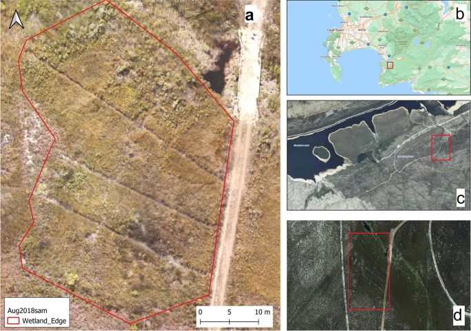
Wetlands harbour a wide range of vital ecosystems. Hence, mapping wetlands is essential to conserving the ecosystems that depend on them. However, the physical nature of wetlands makes fieldwork difficult and potentially erroneous. This study used multispectral UAV aerial photography to map ten wetland plant species in the Fynbos Biome in the Steenbras Nature Reserve. We developed a methodology that used K-Nearest Neighbour (KNN), Support Vector Machine (SVM), and Random Forest (RF) machine learning algorithms to classify ten wetland plant species using the preselected bands and spectral indices. The study identified Normalized green red difference index (NGRDI), Red Green (RG) index, Green, Log Red Edge (LogRE), Normalized Difference Red-Edge (NDRE), Chlorophyll Index Red-Edge (CIRE), Green Ratio Vegetation Index (GRVI), Normalized Difference Water Index (NDWI), Green Normalized Difference Vegetation Index (GNDVI) and Red as pertinent bands and indices for classifying wetland plant species in the Proteaceae, Iridaceae, Restionaceae, Ericaceae, Asteraceae and Cyperaceae families. The classification had an overall accuracy of 87.4% and kappa accuracy of 0.85. Thus, the findings are pertinent to understanding the spectral characteristics of these endemic species. The study demonstrates the potential for UAV-based remote sensing of these endemic species.
中文翻译:
使用无人机多光谱摄影来区分 Fynbos 生物群落渗透湿地中的植物物种
湿地拥有广泛的重要生态系统。因此,绘制湿地地图对于保护依赖湿地的生态系统至关重要。然而,湿地的物理性质使得实地工作变得困难且可能出现错误。这项研究使用多光谱无人机航空摄影绘制了斯廷布拉斯自然保护区凡波斯生物群落中十种湿地植物的地图。我们开发了一种方法,使用 K 最近邻 (KNN)、支持向量机 (SVM) 和随机森林 (RF) 机器学习算法,使用预选的波段和光谱指数对十种湿地植物物种进行分类。该研究确定了归一化绿红差指数(NGRDI)、红绿(RG)指数、绿色对数红边(LogRE)、归一化红边差(NDRE)、叶绿素指数红边(CIRE)、绿比植被指数(GRVI)、归一化水分指数 (NDWI)、绿色归一化植被指数( GNDVI) 和红色作为湿地植物物种分类的相关波段和指数,包括山龙眼科、鸢尾科、Restionaceae、杜鹃花科、菊科和莎草科。该分类的总体准确率为 87.4%,kappa 准确率为 0.85。因此,这些发现有助于了解这些特有物种的光谱特征。该研究证明了基于无人机对这些特有物种进行遥感的潜力。


 京公网安备 11010802027423号