Journal of Coastal Conservation ( IF 2.1 ) Pub Date : 2024-01-11 , DOI: 10.1007/s11852-023-01014-1 Adekunle Ayodotun Osinowo , Samuel Olatunde Popoola
|
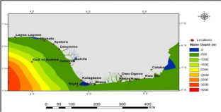
Statistical evaluation of sea’s state is essential for the design and managements of marine structures, operations, shipping and navigation security. For the purpose of coastal navigation, little to no research has been done on the state of the sea along the Nigerian coast. Understanding the local sea’s state can help to lessen the frequency of incidents brought on by ships capsizing. In order to notify users of probable areas where vessel overturning may occur, this study therefore employs the warning and prediction services system created and developed by the Indian National Centre for Ocean Information Services (INCOIS). The system bases its warning advisory on the Boat Safety Index (BSI), a newly developed index with a sufficient threshold. Furthermore, this study investigates the statistical properties of the sea’s state along the Nigerian coast, using daily significant wave height (SWH) and 10 m wind speed (u) data spanning 37 years (1980–2016). The Douglas smooth (wavelet) sea’s state classification prevailed in both cases in the sea. It occurred more in the dry season than in the rainy season. The Douglas smooth (wavelets) sea also prevailed in all months of the year except in August, when the Douglas slight sea had higher occurrences. A spatial analysis using SWH showed that Douglas calm seas are predominant in the eastern waters of the study region. The majority of the study area's waters are dominated by the Douglas smooth (wavelets) sea, which is especially prevalent in the area around Lagos Lagoon. In the western coast of the study area, the Douglas slight sea had the highest frequencies. Very low occurrences of the Douglas moderate and rough seas were observed over the research area. Additionally, a spatial analysis using u revealed that the Douglas smooth (wavelets) sea prevailed in the eastern coast of the study area. The Douglas light and moderate seas increased offshore. In the far western coast of the study location, the Douglas rough to high seas showed very rare occurrences. In all, very little or no occurrence of the Douglas rough to phenomenal seas was observed. Insignificant trends exist for the Douglas smooth (wavelets) sea over the study area. The Boat Safety Index used to evaluate the research location showed that it is considered safe for coastal sailing.
中文翻译:
尼日利亚沿海海域状况统计评估
海洋状况的统计评估对于海洋结构、作业、航运和航行安全的设计和管理至关重要。出于沿海航行的目的,对尼日利亚海岸的海洋状况几乎没有进行过研究。了解当地海域的状况有助于减少船舶倾覆事故的发生频率。为了通知用户可能发生船舶倾覆的区域,本研究采用了印度国家海洋信息服务中心(INCOIS)创建和开发的预警和预测服务系统。该系统的警告建议基于船舶安全指数(BSI),这是一个新开发的具有足够阈值的指数。此外,本研究利用 37 年(1980-2016)的每日有效波高 (SWH) 和 10 m 风速 (u) 数据调查了尼日利亚海岸沿线海洋状态的统计特性。道格拉斯光滑(小波)海的状态分类在这两种情况下均在海洋中占主导地位。其发生在旱季多于雨季。道格拉斯光滑海(小波)在一年中的所有月份中都盛行,但 8 月除外,此时道格拉斯轻微海的发生率较高。使用 SWH 进行的空间分析表明,研究区域东部水域以道格拉斯平静海域为主。研究区域的大部分水域以道格拉斯光滑(小波)海为主,这种情况在拉各斯泻湖周围地区尤其普遍。研究区西海岸以道格拉斯浅海出现频率最高。在研究区域观察到道格拉斯温和海和汹涌海的发生率非常低。此外,使用 u 进行的空间分析表明,研究区域东海岸盛行道格拉斯光滑(小波)海。道格拉斯浅海和温和海向近海增加。在研究地点的远西海岸,道格拉斯波涛汹涌到公海的情况非常罕见。总而言之,很少或没有观察到道格拉斯波涛汹涌的大海。研究区域上空的道格拉斯光滑(小波)海存在不显着的趋势。用于评估研究地点的船舶安全指数表明,沿海航行被认为是安全的。


 京公网安备 11010802027423号