Irrigation Science ( IF 3 ) Pub Date : 2024-01-19 , DOI: 10.1007/s00271-023-00907-1 A. Berry , M. A. Vivier , C. Poblete-Echeverría
|
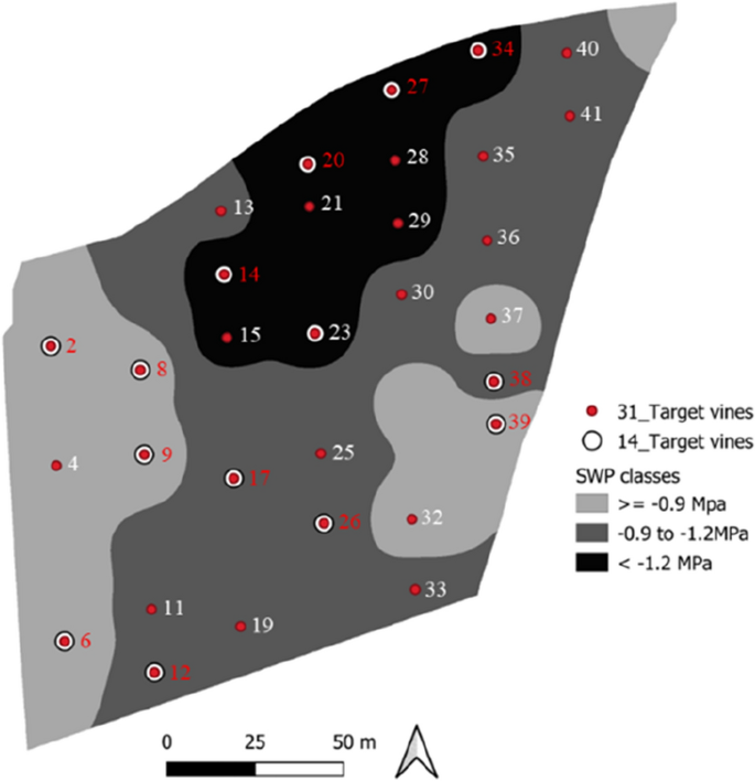
Water stress is a major factor affecting grapevine yield and quality. Standard methods for measuring water stress, such as midday stem water potential (ΨSWP), are laborious and time-consuming for intra-block variability mapping. In this study, we investigate water status variability within a 2.42-ha commercial Cabernet Sauvignon block with a standard vertical trellis system, using remote sensing (RS) tools, specifically canopy fraction-based vegetation indices (VIs) derived from multispectral unmanned aerial vehicle (UAV) imagery, as well as standard reference methods to evaluate soil and plant water status. A total of 31 target vines were monitored for ΨSWP during the whole growing season. The highest variability was at véraison when the highest atmospheric demand occurred. The ΨSWP variability present in the block was contrasted with soil water content (SWC) measurements, showing similar patterns. With spatial and temporal water stress variability confirmed for the block, the relationship between the ΨSWP measured in the field and fraction-based VIs obtained from multispectral UAV data was analysed. Four UAV flights were obtained, and five different VIs were evaluated per target vine across the vineyard. The VI correlation to ΨSWP was further evaluated by comparing VI obtained from canopy fraction (VIcanopy) versus the mean (VImean). It was found that using canopy fraction-based VIs did not significantly improve the correlation with ΨSWP (NDVIcanopy r = 0.57 and NDVImean r = 0.53), however fractional cover (fcover) did seem to show a similar trend to plant water stress with decreasing canopy size corresponding with water stress classes. A subset of 14 target vines were further evaluated to evaluate if additional parameters (maximum temperature, relative humidity (RH), vapour pressure deficit, SWC and fractional cover) could serve as potential water stress indicators for future mapping. Results showed that the integration of NDVIcanopy and NDREmean with additional information could be used as an indicator for mapping water stress variability within a block.
中文翻译:
评估源自多光谱无人机图像的基于冠层部分的植被指数,以绘制商业葡萄园中的水状况变化图
水分胁迫是影响葡萄产量和品质的主要因素。测量水分胁迫的标准方法,例如午间茎水势 (Ψ SWP ),对于块内变异性绘图来说是费力且耗时的。在这项研究中,我们使用遥感 (RS) 工具,特别是从多光谱无人机得出的基于冠层分数的植被指数 (VI),调查了具有标准垂直网格系统的 2.42 公顷商业赤霞珠区块内的水状况变化。无人机)图像,以及评估土壤和植物水分状况的标准参考方法。在整个生长季节共监测了 31 棵目标葡萄藤的 Ψ SWP 。最大的变化发生在转色期,此时大气需求最高。将区块中存在的Ψ SWP变异性与土壤含水量 (SWC) 测量值进行对比,显示出相似的模式。确认该区块的空间和时间水胁迫变异性后,分析了现场测量的Ψ SWP与从多光谱无人机数据获得的基于分数的 VI 之间的关系。获得了四次无人机飞行,并对整个葡萄园的每个目标藤蔓进行了五种不同的 VI 评估。通过比较从冠层分数 (VI canopy ) 获得的 VI 与平均值 (VImean )进一步评估VI 与 Ψ SWP的相关性。结果发现,使用基于冠层分数的 VI 并没有显着改善与 Ψ SWP 的相关性(NDVI冠层r = 0.57 和 NDVI平均值r = 0.53),但是覆盖分数(f cover)似乎确实显示出与植物水相似的趋势与水胁迫等级相对应的冠层尺寸减小的应力。进一步评估了 14 个目标葡萄树的子集,以评估其他参数(最高温度、相对湿度 (RH)、蒸气压不足、SWC 和覆盖率)是否可以作为未来绘图的潜在水分胁迫指标。结果表明,NDVI冠层和 NDRE平均值与附加信息的整合可用作绘制区块内水分胁迫变化的指标。


 京公网安备 11010802027423号