Earth, Planets and Space ( IF 3.362 ) Pub Date : 2024-01-19 , DOI: 10.1186/s40623-023-01940-2 Lucilla Alfonsi , Claudio Cesaroni , Manuel Hernandez-Pajares , Elvira Astafyeva , Simon Bufféral , Panagiotis Elias , Anna Belehaki , Tsagouri Ioanna , Heng Yang , Marco Guerra
|
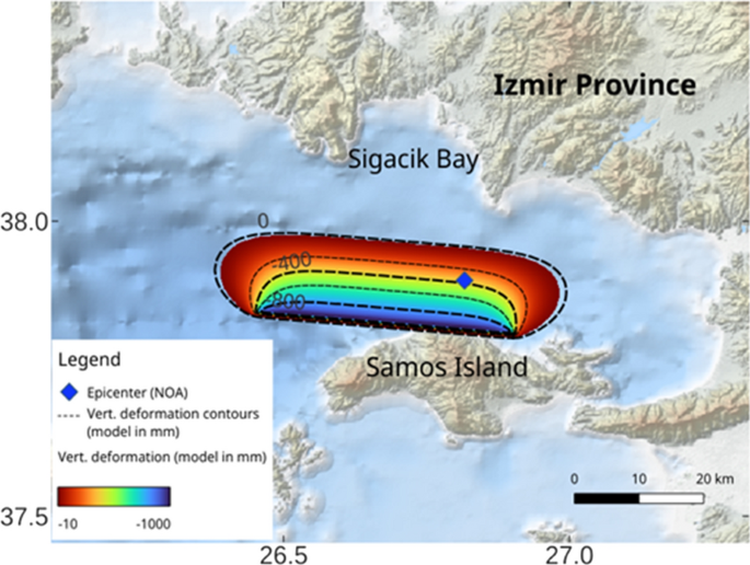
On 30 October 2020 at 11:51 UT, a magnitude 7.0 earthquake occurred in the Dodecanese sea (37.84°N, 26.81°E, 10 km depth) and generated a tsunami with an observed run-up of more than 1 m on the Turkish coasts. Both the earthquake and the tsunami produced acoustic and gravity waves that propagated upward, triggering co-seismic and co-tsunamic ionospheric disturbances. This paper presents a multi-instrumental study of the ionospheric impact of the earthquake and related tsunami based on ionosonde data, ground-based Global Navigation Satellite Systems (GNSS) data and data from DORIS beacons received by Jason3 in the Mediterranean region. Our study focuses on the Total Electron Content to describe the propagation of co-seismic and co-tsunami ionospheric disturbances (CSID, CTID), possibly related to gravity waves triggered by the earthquake and tsunami. We use simultaneous vertical ionosonde soundings to study the interactions between the upper and lower atmosphere, highlighting the detection of acoustic waves generated by the seismic Rayleigh waves reaching the ionosonde locations and propagating vertically up to the ionosphere. The results of this study provide a detailed picture of the Lithosphere-Atmosphere–Ionosphere coupling in the scarcely investigated Mediterranean region and for a relatively weak earthquake.
Graphical abstract
中文翻译:
2020 年萨摩斯地震和海啸的电离层响应
世界标准时间 2020 年 10 月 30 日 11:51,多德卡尼斯海(北纬 37.84°,东经 26.81°,深度 10 公里)发生了 7.0 级地震,并引发了一场海啸,据观测,土耳其海域上升超过 1 m海岸。地震和海啸都产生向上传播的声波和重力波,引发同震和同海啸的电离层扰动。本文基于电离探空仪数据、地面全球导航卫星系统 (GNSS) 数据以及 Jason3 在地中海地区接收到的 DORIS 信标数据,对地震和相关海啸的电离层影响进行了多仪器研究。我们的研究重点是总电子含量来描述同震和同海啸电离层扰动(CSID、CTID)的传播,可能与地震和海啸引发的重力波有关。我们使用同步垂直电离探空仪探测来研究上层和下层大气之间的相互作用,重点关注到达电离探空仪位置并垂直传播到电离层的地震瑞利波产生的声波的检测。这项研究的结果提供了在很少研究的地中海地区和相对较弱的地震中岩石圈-大气-电离层耦合的详细图像。


 京公网安备 11010802027423号