当前位置:
X-MOL 学术
›
IET Radar Sonar Navig.
›
论文详情
Our official English website, www.x-mol.net, welcomes your feedback! (Note: you will need to create a separate account there.)
An unmanned aerial vehicle light detection and ranging Simultaneous Localisation And Mapping algorithm based on factor graph optimisation for tunnel 3D mapping
IET Radar Sonar and Navigation ( IF 1.7 ) Pub Date : 2024-01-26 , DOI: 10.1049/rsn2.12541 Jian Xie 1 , Zhuoping Wu 1 , Bing Wang 1 , Aoshu Xu 1 , Yunfei Chen 1 , Jing Li 1
IET Radar Sonar and Navigation ( IF 1.7 ) Pub Date : 2024-01-26 , DOI: 10.1049/rsn2.12541 Jian Xie 1 , Zhuoping Wu 1 , Bing Wang 1 , Aoshu Xu 1 , Yunfei Chen 1 , Jing Li 1
Affiliation
|
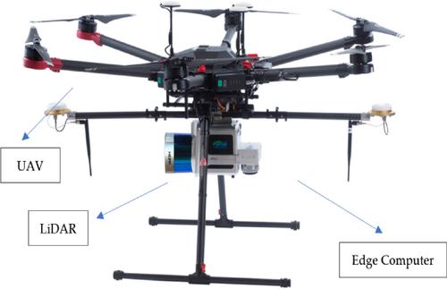
The current mature Simultaneous Localisation And Mapping (SLAM) algorithms, when applied to tunnel scenarios with point cloud degradation and poor lighting conditions, often lead to a sharp increase in the estimated attitude error of the unmanned aerial vehicle (UAV), or even prevent the UAV from moving autonomously due to severe feature degradation. To address the above problems, the authors propose a SLAM algorithm based on factor graph optimisation, Iterative Closest Point and Normal Distributions Transform algorithms. A front-end point cloud registration module and a back-end construction algorithm based on filtering and graph optimisation are designed. To verify the effectiveness of the proposed algorithm, experiments are conducted on KITTI dataset and real tunnel scenes, and compared with LiDAR Odometry and Mapping (LOAM) and lightweight and ground optimised (LeGO)-LOAM algorithms. The results show that the average processing time of the proposed method is about 75 ms, which can meet the real-time requirements of autonomous aerial vehicles. Compared with LOAM and LeGO-LOAM in the real tunnel experiment, the proposed method shows the tunnel 3D map construction.
中文翻译:

基于因子图优化的隧道3D测绘无人机光探测测距同步定位建图算法
目前成熟的同步定位与建图(SLAM)算法,当应用于点云退化、光照条件较差的隧道场景时,往往会导致无人机(UAV)的估计姿态误差急剧增大,甚至无法实现由于严重的功能退化,无人机无法自主移动。针对上述问题,作者提出了一种基于因子图优化、迭代最近点和正态分布变换算法的SLAM算法。设计了前端点云配准模块和基于过滤和图优化的后端构建算法。为了验证所提算法的有效性,在KITTI数据集和真实隧道场景上进行了实验,并与LiDAR里程计和测绘(LOAM)以及轻量级和地面优化(LeGO)-LOAM算法进行了比较。结果表明,该方法的平均处理时间约为75 ms,能够满足自主飞行器的实时性要求。与真实隧道实验中的LOAM和LeGO-LOAM进行比较,该方法展示了隧道3D地图构建。
更新日期:2024-01-27
中文翻译:
基于因子图优化的隧道3D测绘无人机光探测测距同步定位建图算法
目前成熟的同步定位与建图(SLAM)算法,当应用于点云退化、光照条件较差的隧道场景时,往往会导致无人机(UAV)的估计姿态误差急剧增大,甚至无法实现由于严重的功能退化,无人机无法自主移动。针对上述问题,作者提出了一种基于因子图优化、迭代最近点和正态分布变换算法的SLAM算法。设计了前端点云配准模块和基于过滤和图优化的后端构建算法。为了验证所提算法的有效性,在KITTI数据集和真实隧道场景上进行了实验,并与LiDAR里程计和测绘(LOAM)以及轻量级和地面优化(LeGO)-LOAM算法进行了比较。结果表明,该方法的平均处理时间约为75 ms,能够满足自主飞行器的实时性要求。与真实隧道实验中的LOAM和LeGO-LOAM进行比较,该方法展示了隧道3D地图构建。


 京公网安备 11010802027423号