Doklady Earth Sciences ( IF 0.9 ) Pub Date : 2024-02-01 , DOI: 10.1134/s1028334x23602985 Halimi Fahima , Djabri Larbi
|
Abstract
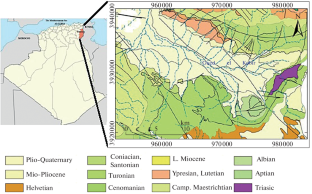
In the Algerian-Tunisian border region lies the Tebessa plain, which belongs to the Saharan Atlas domain and is characterized by a semi-arid climate and high salinity, often rendering the groundwater unusable. The objective of this research is to highlight groundwater salinization using statistical and geostatistical methods to model this spatial heterogeneity. A total of 30 data points were used, and the statistical analysis revealed a strong association between chlorides, sulfates, electrical conductivity, and values significantly exceeding the standards. Surface and directional variograms for EC (electrical conductivity), SO4 (sulfates), and Cl (chlorides) exhibit anisotropy, with the major axis showing a hole effect and a periodicity of 5 km. Geostatistical mapping through ordinary kriging allowed us to identify areas of high salinity and deduce the underlying cause; which is the dissolution of gypsiferous formations. These results were confirmed by thermodynamics and Sr2+/Ca2+ ratio.
中文翻译:
地统计方法对水质评估的贡献:泰贝萨平原(阿尔及利亚最东部)的案例研究
摘要
阿尔及利亚和突尼斯边境地区有泰贝萨平原,属于撒哈拉阿特拉斯地区,气候半干旱,盐度高,地下水经常无法使用。本研究的目的是使用统计和地统计方法来模拟这种空间异质性,以突出地下水盐化。总共使用了 30 个数据点,统计分析显示氯化物、硫酸盐、电导率之间存在很强的关联,并且数值显着超出标准。 EC(电导率)、SO 4(硫酸盐)和Cl(氯化物)的表面和方向变异函数表现出各向异性,长轴显示出空穴效应,周期性为5 km。通过普通克里金法进行地统计绘图使我们能够识别高盐度区域并推断出根本原因;这是石膏地层的溶解。这些结果通过热力学和Sr 2+ /Ca 2+比得到证实。


 京公网安备 11010802027423号