Theoretical and Applied Climatology ( IF 3.4 ) Pub Date : 2024-02-16 , DOI: 10.1007/s00704-024-04873-2 Md Babor Ali , Saleha Jamal , Manal Ahmad , Mohd Saqib
|
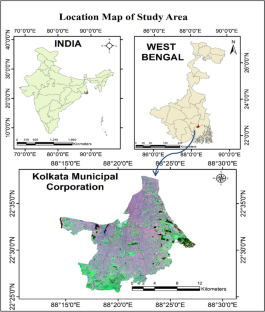
The research article delves into the background of urban land use and land cover (LULC) change, specifically focusing on built-up expansion, and underscores its significant implications on land surface temperature (LST) and the urban heat island (UHI) phenomenon. This research aims to unravel the intricate associations among urban green cover, built-up index, and surface temperature, specifically within the spatial confines of the Kolkata Municipal Corporation. The primary objective is to comprehensively understand how the conversion of green spaces into built-up areas influences land surface temperature and, consequently, the urban heat island effect. Employing a geospatial approach, the study utilizes normalized differential vegetation index (NDVI), normalized differential built-up index (NDBI), and land surface temperature (LST) data extracted from Landsat imagery spanning four temporal points (1990, 2000, 2010, and 2020). The borough-level analysis offers a micro-level perspective within the limited urban space of Kolkata Municipal Corporation. Correlation analyses and scatter diagrams are employed as tools to scrutinize the complex relationships between these variables, providing a robust methodology for the investigation. The research underscores the significant impact of urbanization on the study area, revealing a consistent trend of converting green spaces into built-up areas over the studied decades. This transformation has led to a reduction in green coverage and a concurrent increase in surface temperatures. The study reveals compelling correlations and patterns through NDVI, NDBI, and LST analyses, emphasizing the urgency for serious attention from urban planners, environmentalists, and ecologists. The findings highlight the pressing need for the development of appropriate policy frameworks to ensure the future sustainability and health of cities.
中文翻译:
使用地理空间方法解开城市绿化覆盖率、建成指数和地表温度之间的复杂关联:加尔各答市政公司可持续城市的微观研究
该研究文章深入研究了城市土地利用和土地覆盖(LULC)变化的背景,特别关注建成区扩张,并强调了其对地表温度(LST)和城市热岛(UHI)现象的重大影响。这项研究旨在揭示城市绿化覆盖率、建成指数和地表温度之间复杂的关联,特别是在加尔各答市政公司的空间范围内。主要目标是全面了解绿地转变为建成区如何影响地表温度,从而影响城市热岛效应。该研究采用地理空间方法,利用从跨越四个时间点(1990 年、2000 年、2010 年和2020)。行政区层面的分析在加尔各答市政公司有限的城市空间内提供了微观层面的视角。采用相关分析和散点图作为工具来仔细检查这些变量之间的复杂关系,为调查提供可靠的方法。该研究强调了城市化对研究区域的重大影响,揭示了研究几十年来将绿色空间转变为建成区的一致趋势。这种转变导致绿化覆盖率减少,同时地表温度上升。该研究通过 NDVI、NDBI 和 LST 分析揭示了令人信服的相关性和模式,强调了城市规划者、环保主义者和生态学家认真关注的紧迫性。研究结果强调迫切需要制定适当的政策框架,以确保城市未来的可持续性和健康。


 京公网安备 11010802027423号