Autonomous Agents and Multi-Agent Systems ( IF 1.9 ) Pub Date : 2024-02-19 , DOI: 10.1007/s10458-024-09635-y Mohammad Saleh Teymouri , Subhrajit Bhattacharya
|
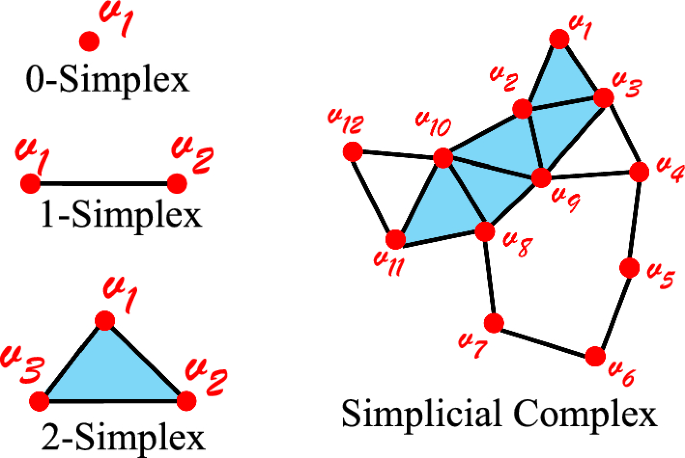
In this paper, we address the problem of autonomous multi-robot mapping, exploration and navigation in unknown, GPS-denied indoor or urban environments using a team of robots equipped with directional sensors with limited sensing capabilities and limited computational resources. The robots have no a priori knowledge of the environment and need to rapidly explore and construct a map in a distributed manner using existing landmarks, the presence of which can be detected using onboard senors, although little to no metric information (distance or bearing to the landmarks) is available. In order to correctly and effectively achieve this, the presence of a necessary density/distribution of landmarks is ensured by design of the urban/indoor environment. We thus address this problem in two phases: (1) During the design/construction of the urban/indoor environment we can ensure that sufficient landmarks are placed within the environment. To that end we develop a filtration-based approach for designing strategic placement of landmarks in an environment. (2) We develop a distributed algorithm which a team of robots, with no a priori knowledge of the environment, can use to explore such an environment, construct a topological map requiring no metric/distance information, and use that map to navigate within the environment. This is achieved using a topological representation of the environment (called a Landmark Complex), instead of constructing a complete metric/pixel map. The representation is built by the robot as well as used by them for navigation through a balanced strategy involving exploration and exploitation. We use tools from homology theory for identifying “holes” in the coverage/exploration of the unknown environment and hence guide the robots towards achieving a complete exploration and mapping of the environment. Our simulation results demonstrate the effectiveness of the proposed metric-free topological (simplicial complex) representation in achieving exploration, localization and navigation within the environment.
中文翻译:
使用低成本机器人团队在没有 GPS 的城市环境中进行基于地标的分布式拓扑测绘和导航
在本文中,我们使用一组配备有有限传感能力和有限计算资源的方向传感器的机器人来解决未知、无法使用 GPS 的室内或城市环境中的自主多机器人测绘、探索和导航问题。机器人对环境没有先验知识,需要使用现有地标以分布式方式快速探索和构建地图,可以使用机载传感器检测到地标的存在,尽管几乎没有度量信息(到机器人的距离或方位)地标)可用。为了正确有效地实现这一目标,通过城市/室内环境的设计来确保地标的必要密度/分布。因此,我们分两个阶段解决这个问题:(1)在城市/室内环境的设计/施工过程中,我们可以确保在环境中放置足够的地标。为此,我们开发了一种基于过滤的方法来设计环境中地标的战略布局。(2)我们开发了一种分布式算法,一组机器人在没有环境先验知识的情况下可以用来探索这样的环境,构建不需要度量/距离信息的拓扑图,并使用该地图在环境中导航环境。这是通过使用环境的拓扑表示(称为Landmark Complex)来实现的,而不是构建完整的度量/像素图。该表示由机器人构建,并由机器人用于通过涉及探索和利用的平衡策略进行导航。我们使用同源理论的工具来识别未知环境的覆盖/探索中的“漏洞”,从而引导机器人实现对环境的完整探索和映射。我们的模拟结果证明了所提出的无度量拓扑(单纯复形)表示在实现环境内探索、定位和导航方面的有效性。


 京公网安备 11010802027423号