当前位置:
X-MOL 学术
›
Remote Sens. Ecol. Conserv.
›
论文详情
Our official English website, www.x-mol.net, welcomes your feedback! (Note: you will need to create a separate account there.)
Tree species diversity mapping from spaceborne optical images: The effects of spectral and spatial resolution
Remote Sensing in Ecology and Conservation ( IF 5.5 ) Pub Date : 2024-02-19 , DOI: 10.1002/rse2.383 Xiang Liu 1 , Julian Frey 2 , Catalina Munteanu 3 , Martin Denter 1 , Barbara Koch 1
Remote Sensing in Ecology and Conservation ( IF 5.5 ) Pub Date : 2024-02-19 , DOI: 10.1002/rse2.383 Xiang Liu 1 , Julian Frey 2 , Catalina Munteanu 3 , Martin Denter 1 , Barbara Koch 1
Affiliation
|
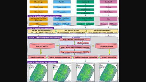
Increasingly available spaceborne sensors provide unprecedented opportunities for large‐scale, timely and continuous tree species diversity (TSD) monitoring. However, given differences in spectral and spatial resolutions, the choice of sensor is not always straightforward. In this work, we investigated the effects of spatial and spectral resolutions for four spaceborne sensors (RapidEye, Landsat‐8, Sentinel‐2 and PlanetScope) on TSD mapping in an area of approximately 4000 km2 within the Black Forest, Germany. We employed a random forest (RF) regression model to predict Shannon–Wiener diversity based on seven types of spectral heterogeneity metrics (texture, coefficient of variation, Rao's Q, convex hull volume, spectral angle mapper, convex hull area and spectral species diversity) and a full survey dataset from 135 one‐ha sample plots. We compared the RF model's performance across sensors and spatial resolutions. Our results demonstrated that the Sentinel‐2‐based TSD model achieved the highest accuracy (mean R 2 : 0.477, mean root‐mean‐square error (RMSE): 0.274). The RapidEye‐based TSD model produced lower accuracy (mean R 2 : 0.346, mean RMSE: 0.303), but it was better than the PlanetScope‐ and Landsat‐based TSD models. The 10 m (for Sentinel‐2 and RapidEye) and 15 m (for PlanetScope) were the best spatial resolutions for predicting TSD. The NIR band was the most favourable spectral band for predicting TSD. Texture metrics and Rao's Q outperformed the other spectral heterogeneity metrics. Our results highlighted that spaceborne optical imagery (especially Sentinel‐2) can be successfully used for large‐scale TSD mapping but that the choice of sensors can significantly affect the resulting mapping accuracy in temperate montane forests.
中文翻译:

从星载光学图像绘制树种多样性图:光谱和空间分辨率的影响
越来越多的星载传感器为大规模、及时和连续的树种多样性(TSD)监测提供了前所未有的机会。然而,考虑到光谱和空间分辨率的差异,传感器的选择并不总是那么简单。在这项工作中,我们研究了四个星载传感器(RapidEye、Landsat-8、Sentinel-2 和 PlanetScope)的空间和光谱分辨率对约 4000 km 区域内 TSD 测绘的影响2 德国黑森林境内。我们采用随机森林(RF)回归模型来预测基于七种类型的光谱异质性指标(纹理、变异系数、Rao's Q、凸包体积、光谱角度映射器、凸包面积和光谱物种多样性)的香农-维纳多样性。以及来自 135 个一公顷样地的完整调查数据集。我们比较了射频模型在传感器和空间分辨率上的性能。我们的结果表明,基于 Sentinel‐2 的 TSD 模型达到了最高的准确度(平均右 2 :0.477,平均均方根误差(RMSE):0.274)。基于 RapidEye 的 TSD 模型产生的准确度较低(平均右 2 :0.346,平均 RMSE:0.303),但它优于基于 PlanetScope 和 Landsat 的 TSD 模型。10 m(对于 Sentinel‐2 和 RapidEye)和 15 m(对于 PlanetScope)是预测 TSD 的最佳空间分辨率。NIR 波段是预测 TSD 最有利的光谱波段。纹理指标和 Rao 的 Q 优于其他光谱异质性指标。我们的结果强调,星载光学图像(尤其是 Sentinel-2)可以成功用于大规模 TSD 测绘,但传感器的选择会显着影响温带山地森林测绘的准确性。
更新日期:2024-02-19
中文翻译:
从星载光学图像绘制树种多样性图:光谱和空间分辨率的影响
越来越多的星载传感器为大规模、及时和连续的树种多样性(TSD)监测提供了前所未有的机会。然而,考虑到光谱和空间分辨率的差异,传感器的选择并不总是那么简单。在这项工作中,我们研究了四个星载传感器(RapidEye、Landsat-8、Sentinel-2 和 PlanetScope)的空间和光谱分辨率对约 4000 km 区域内 TSD 测绘的影响


 京公网安备 11010802027423号