GPS Solutions ( IF 4.9 ) Pub Date : 2024-02-21 , DOI: 10.1007/s10291-024-01619-5 Jie Li , Dongkai Yang , Feng Wang , Xuebao Hong , Lei Yang
|
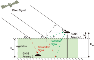
In land surface remote sensing using Global Navigation Satellite System reflectometry (GNSS-R) signals, it is common to observe signal coupling between the reflections from the soil surface and vegetation. But most recent research focuses on either bare soil or single vegetation. The vegetation significantly reduces the amplitude of the GNSS signal and increases the standard deviation (STD) of the carrier phase and pseudorange calculations. This study proposes a solution that uses GNSS transmission reflectometry (GNSS-TR) and wavelet transform to decouple signals reflected off vegetation-covered and bare soil surfaces. This coupling persists despite the ability of wavelet transform to initially separate the signal-to-noise ratio (SNR) sequences of GNSS reflected signals into different frequency components. This study uses the power of GNSS transmission signals, which carry almost exclusively vegetation information, as a priori information input to calibrate the influence of vegetation on the reflected signal from the soil surface to maximize the decoupling of the two reflected signals. Furthermore, signals from above- and below-vegetation GNSS antennas were simultaneously collected using a low-cost, dual-channel GNSS chipset, which can increase GNSS signal processing channels while reducing equipment costs. The results show that the solution proposed in this study can reach a correlation coefficient of 0.96 between the retrieval and in situ soil moisture content (SMC), and the root mean square error (RMSE) is reduced to 0.013 cm3/cm3. Moreover, the transmitted signal power, pseudorange STD, and carrier phase STD showed a clear trend with the vegetation growth status (VGS).
中文翻译:
用于确定土壤湿度和植被生长状况的双天线 GNSS 方法
在使用全球导航卫星系统反射计(GNSS-R)信号的地表遥感中,通常会观察土壤表面和植被反射之间的信号耦合。但最近的研究主要集中在裸土或单一植被上。植被显着降低了 GNSS 信号的幅度,并增加了载波相位和伪距计算的标准偏差 (STD)。本研究提出了一种解决方案,使用 GNSS 传输反射计 (GNSS-TR) 和小波变换来解耦从植被覆盖和裸露土壤表面反射的信号。尽管小波变换最初能够将 GNSS 反射信号的信噪比 (SNR) 序列分离成不同的频率分量,但这种耦合仍然存在。这项研究利用几乎只携带植被信息的 GNSS 传输信号的功率作为先验信息输入来校准植被对土壤表面反射信号的影响,以最大限度地解耦两个反射信号。此外,使用低成本双通道 GNSS 芯片组同时收集植被上方和下方 GNSS 天线的信号,这可以增加 GNSS 信号处理通道,同时降低设备成本。结果表明,本研究提出的解决方案可以使反演与原位土壤含水量(SMC)相关系数达到0.96,均方根误差(RMSE)降低至0.013 cm 3 /cm 3。此外,发射信号功率、伪距STD和载波相位STD随植被生长状态(VGS)呈现出明显的趋势。


 京公网安备 11010802027423号