Acta Geophysica ( IF 2.3 ) Pub Date : 2024-02-23 , DOI: 10.1007/s11600-024-01293-8 Ines Gharnouki , Jalel Aouissi , Sihem Benabdallah , Yves Tramblay
|
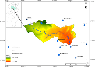
Precipitation is a key component in hydrologic processes. It plays an important role in hydrological modeling and water resource management. However, many regions suffer from limited and data scarcity due to the lack of ground-based rain gauge networks. The main objective of this study is to evaluate other source of rainfall data such as remote sensing data (three different satellite-based precipitation products (CHIRPS, PERSIANN, and GPM) and a reanalysis (ERA5) against ground-based data, which could provide complementary rainfall information in semiarid catchment of Tunisia (Haffouz catchment), for the period between September 2000 and August 2018. These remotely sensed-data are compared for the first time with observations in a semiarid catchment in Tunisia.
Twelve rain gauges and two different interpolation methods (inverse distance weight and ordinary kriging) were used to compute a set of interpolated precipitation reference fields. The evaluation was performed at daily, monthly, and yearly time scales and at different spatial scales, using several statistical metrics. The results showed that the two interpolation methods give similar precipitation estimates at the catchment scale. According to the different statistical metrics, CHIRPS showed the most satisfactory results followed by PERSIANN which performed well in terms of correlation but overestimated precipitations spatially over the catchment. GPM underestimates the precipitation considerably, but it gives a satisfactory performance temporally. ERA5 shows a very good performance at daily, monthly, and yearly timescale, but it is unable to represent the spatial variability distribution of precipitation for this catchment. This study concluded that satellite-based precipitation products or reanalysis data can be useful in semiarid regions and data-scarce catchments, and it may provide less costly alternatives for data-poor regions.
中文翻译:
评估突尼斯半干旱流域的卫星变化并重新分析降雨产品
降水是水文过程的关键组成部分。它在水文建模和水资源管理中发挥着重要作用。然而,由于缺乏地面雨量计网络,许多地区的数据有限且稀缺。本研究的主要目的是评估其他来源的降雨数据,例如遥感数据(三种不同的基于卫星的降水产品(CHIRPS、PERSIANN 和 GPM)以及针对地面数据的再分析 (ERA5),这可以提供突尼斯半干旱流域(Haffouz 流域)2000 年 9 月至 2018 年 8 月期间的补充降雨信息。这些遥感数据首次与突尼斯半干旱流域的观测数据进行比较。
使用十二个雨量计和两种不同的插值方法(反距离权重和普通克里金法)来计算一组插值降水参考场。使用多种统计指标,在每日、每月和每年的时间尺度和不同的空间尺度上进行评估。结果表明,两种插值方法在流域尺度上给出了相似的降水量估计值。根据不同的统计指标,CHIRPS 显示出最令人满意的结果,其次是 PERSIANN,其在相关性方面表现良好,但高估了流域的空间降水量。GPM 大大低估了降水量,但它在时间上给出了令人满意的表现。ERA5在日、月、年时间尺度上表现出非常好的性能,但无法代表该流域降水的空间变异分布。这项研究的结论是,基于卫星的降水产品或再分析数据在半干旱地区和数据稀缺的流域可能有用,并且可以为数据匮乏的地区提供成本较低的替代方案。


 京公网安备 11010802027423号