Theoretical and Applied Climatology ( IF 3.4 ) Pub Date : 2024-02-23 , DOI: 10.1007/s00704-024-04882-1 Yizhen Du , Jie Ni , Ren Li , Tonghua Wu , Guojie Hu , Shuhua Yang , Xuefei Weng
|
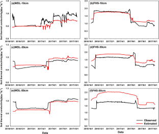
Soil thermal conductivity (STC), which describes the ability of soil to transfer heat, is critical to understanding the thermal regime. Simulations of the heat of the permafrost regions on the Qinghai-Tibet Plateau (QTP) are currently inaccurate. This is partly because the current STC models used in the land surface models are not adequate to accurately reflect the characteristics of the ice-water phase change. Here, the new STC model was developed by dividing three different stages. Our analyses revealed that the soil moisture (\({\theta }_{\mathrm{w}}\)) undergoes a rapid phase change in the − 2.5 ~ 0 ℃, where minor temperature changes could cause larger \({\theta }_{\mathrm{w}}\) changes. When the temperature is below − 2.5 ℃, the \({\theta }_{\mathrm{w}}\) mostly remains stable. Considering the influence of various factors in different temperature ranges, an improved STC model was proposed by piecewise fitting at 0 ℃ and − 2.5 ℃ for the depths of 10–50 cm. Independent test results showed that the new model significantly improved simulation accuracy of STC in permafrost regions and was better able to reflect it changing characteristics, especially in the 50 cm depth. Lastly, the daily STC product in the permafrost region of the QTP was estimated with the new model. The average STC during 1982 to 2020 was about 0.495 Wm−1K−1, showing a spatial pattern of low in the northwest and high in the southeast. In addition, the STC showed a tiny increasing trend at a rate of 0.008 Wm−1K−1/10a. Spatially, the regions with the highest rates of increase were concentrated in the eastern, southeastern, and south-western regions, which comprise mostly unstable and extremely unstable permafrost. This study deepened our understanding of the STC during the freeze–thaw cycle and provides data products for further studies on the soil thermal state in permafrost regions.
中文翻译:
青藏高原多年冻土区土壤导热系数参数化模型及其应用
土壤热导率 (STC) 描述了土壤传递热量的能力,对于了解热状况至关重要。目前对青藏高原多年冻土区热量的模拟并不准确。部分原因是目前陆面模型使用的STC模型不足以准确反映冰水相变的特征。在这里,新的STC模型是通过划分三个不同的阶段来开发的。我们的分析表明,土壤湿度(\({\theta }_{\mathrm{w}}\) )在 − 2.5 ~ 0 ℃ 范围内经历快速相变,其中较小的温度变化可能会导致较大的\({\theta }_{\mathrm{w}}\)发生变化。当温度低于 − 2.5 ℃ 时,\({\theta }_{\mathrm{w}}\)基本保持稳定。考虑到不同温度范围内各种因素的影响,通过在0 ℃和− 2.5 ℃下对10~50 cm深度进行分段拟合,提出了改进的STC模型。独立试验结果表明,新模型显着提高了多年冻土区STC的模拟精度,能够更好地反映其变化特征,特别是在50 cm深度。最后,利用新模型对青藏高原多年冻土区的日STC产物进行了估算。1982—2020年平均海温约为0.495 Wm -1 K -1,呈现西北低、东南高的空间格局。此外,STC以0.008 Wm -1 K -1 /10a的速率呈现微小的增加趋势。从空间上看,增加率最高的区域集中在东部、东南部和西南部地区,这些地区大多由不稳定和极不稳定的多年冻土组成。本研究加深了我们对冻融循环过程中STC的认识,为进一步研究多年冻土区土壤热状态提供了数据产品。


 京公网安备 11010802027423号