GPS Solutions ( IF 4.9 ) Pub Date : 2024-02-27 , DOI: 10.1007/s10291-024-01620-y Tianyang Hu , Xiaohua Xu , Jia Luo
|
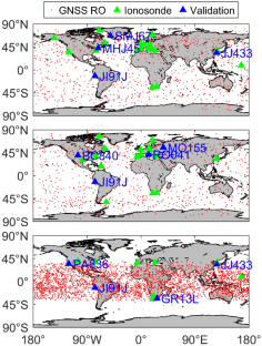
The International Reference Ionosphere (IRI) model is a widely used empirical model to describe ionospheric climatology. However, IRI represents the monthly averages of the ionospheric parameters, which makes it difficult to capture the local and short-term ionospheric variations. To overcome this limitation, we propose a data ingestion method using a combination of ground-based and space-borne observations. The ionospheric parameters from ground-based Global Navigation Satellite System (GNSS), ionosondes, space-borne GNSS radio occultation and satellite altimetry observations are ingested into the IRI-2020 model to improve its accuracy. The outputs of the ingested IRI (IRIinge) are assessed by case study and statistical analysis, with reference to independent ionosonde observations and global ionospheric maps. The case study shows that IRIinge expresses the diurnal and local variations of the ionosphere better than the standard IRI (IRIstan) in both high and low solar activity periods. The relative error of ionospheric electron density profiles from IRIinge is generally less than 10%, and the vertical total electron content from IRIinge has an accuracy improvement of 39.0% compared to that from IRIstan. The statistical analysis shows that IRIinge performs more stable than IRIstan, and its output generally has smaller REs and root-mean-square errors, especially in daytime and storm time. The proposed method significantly improves IRI-2020 on the accuracy of the output parameters and the ability to present the short-term variations of the ionosphere.
中文翻译:
IRI-2020 模型的多源数据摄取:地基和星载观测的结合
国际参考电离层 (IRI) 模型是广泛使用的描述电离层气候学的经验模型。然而,IRI代表电离层参数的月平均值,这使得难以捕捉局部和短期的电离层变化。为了克服这一限制,我们提出了一种结合地面和星载观测的数据摄取方法。IRI-2020 模型将来自地面全球导航卫星系统 (GNSS)、电离探空仪、星载 GNSS 无线电掩星和卫星测高观测的电离层参数纳入 IRI-2020 模型中,以提高其准确性。摄入 IRI (IRI inge ) 的输出通过案例研究和统计分析进行评估,并参考独立的电离探空仪观测结果和全球电离层地图。案例研究表明,在太阳活动高峰期和低谷期, IRI inge都比标准 IRI (IRI stan )更好地表达了电离层的昼夜和局部变化。IRI inge电离层电子密度剖面相对误差一般小于10%,IRI inge垂直总电子含量精度较IRI stan提高39.0% 。统计分析表明,IRI inge比IRI stan表现更稳定,其输出普遍具有较小的RE和均方根误差,特别是在白天和暴风雨时段。该方法显着提高了IRI-2020输出参数的准确性以及呈现电离层短期变化的能力。


 京公网安备 11010802027423号