International Journal of Disaster Risk Science ( IF 4 ) Pub Date : 2024-03-01 , DOI: 10.1007/s13753-024-00545-x Chenchen Qiu , Lijun Su , Alessandro Pasuto , Giulia Bossi , Xueyu Geng
|
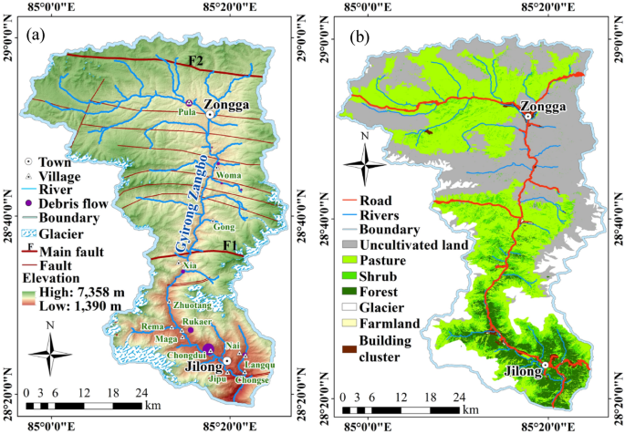
A reliable economic risk map is critical for effective debris-flow mitigation. However, the uncertainties surrounding future scenarios in debris-flow frequency and magnitude restrict its application. To estimate the economic risks caused by future debris flows, a machine learning-based method was proposed to generate an economic risk map by multiplying a debris-flow hazard map and an economic vulnerability map. We selected the Gyirong Zangbo Basin as the study area because frequent severe debris flows impact the area every year. The debris-flow hazard map was developed through the multiplication of the annual probability of spatial impact, temporal probability, and annual susceptibility. We employed a hybrid machine learning model—certainty factor-genetic algorithm-support vector classification—to calculate susceptibilities. Simultaneously, a Poisson model was applied for temporal probabilities, while the determination of annual probability of spatial impact relied on statistical results. Additionally, four major elements at risk were selected for the generation of an economic loss map: roads, vegetation-covered land, residential buildings, and farmland. The economic loss of elements at risk was calculated based on physical vulnerabilities and their economic values. Therefore, we proposed a physical vulnerability matrix for residential buildings, factoring in impact pressure on buildings and their horizontal distance and vertical distance to debris-flow channels. In this context, an ensemble model (XGBoost) was used to predict debris-flow volumes to calculate impact pressures on buildings. The results show that residential buildings occupy 76.7% of the total economic risk, while road-covered areas contribute approximately 6.85%. Vegetation-covered land and farmland collectively represent 16.45% of the entire risk. These findings can provide a scientific support for the effective mitigation of future debris flows.
中文翻译:
利用机器学习方法评估未来泥石流的经济风险
可靠的经济风险图对于有效缓解泥石流至关重要。然而,未来泥石流频率和强度的不确定性限制了其应用。为了估计未来泥石流造成的经济风险,提出了一种基于机器学习的方法,通过将泥石流危害图与经济脆弱性图相乘来生成经济风险图。我们选择吉隆藏布盆地作为研究区,因为该地区每年都会频繁发生严重泥石流灾害。泥石流灾害图是通过乘以年度空间影响概率、时间概率和年度敏感性而绘制的。我们采用混合机器学习模型——确定性因子-遗传算法-支持向量分类——来计算敏感性。同时,泊松模型应用于时间概率,而空间影响的年度概率的确定则依赖于统计结果。此外,还选择了四个主要风险要素来生成经济损失图:道路、植被覆盖的土地、住宅建筑和农田。风险要素的经济损失是根据物理脆弱性及其经济价值计算的。因此,我们提出了住宅建筑的物理脆弱性矩阵,考虑了建筑物的冲击压力及其与泥石流通道的水平距离和垂直距离。在这种情况下,使用集合模型(XGBoost)来预测泥石流体积,以计算对建筑物的冲击压力。结果显示,住宅建筑占总经济风险的76.7%,道路覆盖面积约占6.85%。植被覆盖的土地和农田合计占全部风险的 16.45%。这些发现可为未来泥石流的有效缓解提供科学依据。


 京公网安备 11010802027423号