Pure and Applied Geophysics ( IF 2 ) Pub Date : 2024-03-05 , DOI: 10.1007/s00024-024-03435-x Rapelang E. Simon , J. G. King , L. C. Moffat , M. D. Moidaki , M. T. O. Kwadiba , K. G. Jackson , O. Ntibinyane , R. T. Ranganai
|
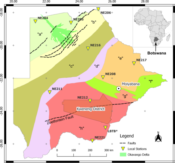
On the 3rd April 2017 a widely felt Moiyabana earthquake shook Botswana and the rest of southern Africa. Previous Moiyabana earthquake locations used mainly teleseismic or regional seismograms; and/or non-seismic methods which include Synthetic Aperture Radar (InSAR), and magnetotelluric (MT). These results did not agree, as evidenced by the depth of the earthquake that ranged from zero to 30 km (i.e. indicating either a man-made event or a natural event); thus motivating us to re-assess the location parameters. Unfiltered seismic waveform data from the recent project of the Network of Autonomously Recording Seismographs (NARS) in Botswana was complimented with stations from the International Monitoring System (IMS) to relocate the event. Relocated parameters are origin time, epicentre, focal depth, and magnitude. Geotool software from the Comprehensive Nuclear Test Ban Treaty Organization (CTBTO), and the Regional Seismic Travel Time model (RSTT) were used to process vertical components waveforms from 9 NARS and 32 IMS stations. Geotool results are: earthquake epicentre (22.645 °S: 25.220 °E); origin time of 17:40:16.9 (UTC); hypocentral depth range of 22 to 24 km; body magnitude (mb) and local magnitude (ml) of 6.3 ± 0.6 and 6.0 ± 0.8, respectively. RSTT results are: earthquake epicentre (22.667 °S: 25.257 °E); origin time of 17:40:16.95 (UTC); hypocentral depth of 25 km; and mb of 6.65 ± 0.03. The seismological location parameters from Geotool and RSTT, agree very well within experimental uncertainties with the non-seismic geophysical methods.
中文翻译:
使用本地自主记录地震仪网络和国际监测系统站的地震数据重新定位 2017 年 4 月 3 日博茨瓦纳莫亚巴纳地震
2017 年 4 月 3 日,一场广泛震感的莫亚巴纳地震震动了博茨瓦纳和南部非洲其他地区。以前的莫亚巴纳地震定位主要使用远震或区域地震图;和/或非地震方法,包括合成孔径雷达(InSAR)和大地电磁(MT)。这些结果并不相符,地震深度为 0 至 30 公里(即表明是人为事件或自然事件);从而促使我们重新评估位置参数。来自博茨瓦纳自主记录地震仪网络 (NARS) 最近项目的未经过滤的地震波形数据得到了国际监测系统 (IMS) 站点的称赞,以重新定位该事件。重定位参数包括起源时间、震中、震源深度和震级。使用全面禁止核试验条约组织 (CTBTO) 的 Geotool 软件和区域地震走时模型 (RSTT) 来处理来自 9 个 NARS 和 32 个 IMS 台站的垂直分量波形。Geotool结果为:地震震中(22.645°S:25.220°E);起始时间 17:40:16.9 (UTC);震源深度范围为22至24公里;身体强度 (mb) 和局部强度 (ml) 分别为 6.3 ± 0.6 和 6.0 ± 0.8。RSTT结果为:地震震中(22.667°S:25.257°E);起始时间 17:40:16.95 (UTC);震源深度25公里;mb 为 6.65 ± 0.03。Geotool 和 RSTT 的地震位置参数在实验不确定性范围内与非地震地球物理方法非常吻合。


 京公网安备 11010802027423号