Environmental Earth Sciences ( IF 2.8 ) Pub Date : 2024-03-05 , DOI: 10.1007/s12665-024-11452-1 Zhijie Zheng , Wei Liu , Jie Zeng , Fuping Gan , Xiuhua Lu
|
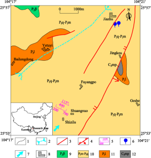
The direction of drilling wells in the plateau slope area is toward finding local favorable water-rich blocks, which are relative groundwater accumulation areas under the control of structure, lithology, and landform. These areas often have obvious geological boundary conditions (such as the presence of a water resisting layer in the vertical direction, the development of a fault fracture zone in the plane), and their corresponding physical boundary often has a relatively low or high resistivity to the surrounding rock. In this paper, the comprehensive geophysical method is used to study the application of water prospecting in the plateau slope of Shuangnuo village, Fuyuan, Yunnan Province. First, according to the hydrogeological conditions (the development of a fault fracture zone and clastic rock is unknown), the plane distribution range and vertical development of the low-resistivity abnormal fault fracture zone are determined using the electrical resistivity tomography (less than 100 m) and audio magnetotelluric methods (100–500 m). Vertically, the development depth and thickness of the clastic rock aquifuge (P1l) are determined using the audio frequency magnetotelluric method, which provides a basis for the maximum depth of the borehole layout. The combination of the electrical resistivity tomography and audio frequency magnetotelluric methods can delineate the favorable water-rich block in the study area well and verify that the study area has the prerequisite to become a water prospecting target. To determine the best location of the borehole layout, a combination of the composite profiling, microtremor horizontal-to-vertical spectral ratio (HVSR), apparent resistivity sounding, and K-reflection coefficient methods are carried out in the favorable water-rich block, which delineated by the electrical resistivity tomography and audio frequency magnetotelluric methods. The optimal borehole layout location is determined through the synchronous low resistivity anomaly of the composite profiling method, and the synchronous low resistivity anomaly is determined as a karst fracture zone (qualitative determination) in combination with the HVSR high-value anomaly of the microtremor method. The development depth of the karst fracture zone is finally determined by using the apparent resistivity sounding and K curves. This study reveals that the depth of the drilled hole is 243.5 m, and the water inflow is 144.3 m3/ day, successfully solving the serious water shortage problem in the local area. The case study results show that the combination of geophysical prospecting methods, namely, the electrical resistivity tomography, audio frequency magnetotelluric, composite profiling, microtremor, apparent resistivity sounding, and k-reflection coefficient methods, is effective for water exploration in the plateau slope zone.
中文翻译:
高原斜坡带地下水综合物探方法——以云南省富源市双糯村为例
高原斜坡区打井的方向是寻找局部有利的富水区块,这些区块是构造、岩性、地貌控制下的相对地下水富集区。这些地区往往具有明显的地质边界条件(如垂直方向存在阻水层、平面上发育断层破碎带等),其相应的物理边界往往对地表电阻率较低或较高。围岩。本文采用综合地球物理方法对云南省富源市双糯村高原边坡找水应用进行研究。首先,根据水文地质条件(断层破碎带和碎屑岩发育情况未知),利用电阻率层析成像(小于100 m)确定低电阻率异常断层破碎带的平面分布范围和垂向发育程度。 )和音频大地电磁方法(100–500 m)。纵向上,利用音频大地电磁法确定了碎屑岩隔水层(P 1 l)的发育深度和厚度,为钻孔布置的最大深度提供了依据。电阻率层析成像与音频大地电磁方法相结合,可以很好地圈定研究区有利富水区块,验证研究区具备成为找水目标的先决条件。为了确定钻孔布局的最佳位置,在有利的富水区块中进行了综合剖面、微动水平垂直谱比(HVSR)、视电阻率测深和K反射系数方法的组合,它是通过电阻率断层扫描和音频大地电磁方法描绘的。通过复合剖面法同步低阻异常确定最佳钻孔布置位置,并结合微动法HVSR高值异常确定同步低阻异常为岩溶破碎带(定性判定)。利用视电阻率测深和K曲线最终确定岩溶破碎带的发育深度。本次研究发现,钻孔深度243.5 m,涌水量144.3 m 3 /天,成功解决了当地严重的缺水问题。实例研究结果表明,电阻率层析、音频大地电磁、综合剖面、微震、视电阻率测深、k反射系数等地球物理勘探方法相结合,对高原斜坡带水源勘探是有效的。 。


 京公网安备 11010802027423号