Theoretical and Applied Climatology ( IF 3.4 ) Pub Date : 2024-03-05 , DOI: 10.1007/s00704-024-04914-w Vijendra Kumar , Kul Vaibhav Sharma , Quoc Bao Pham , Ayush Kumar Srivastava , Chandra Bogireddy , S. M. Yadav
|
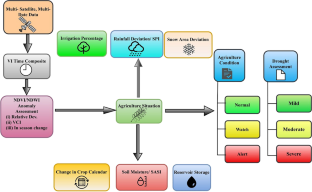
The use of remote sensing for monitoring and managing droughts is examined in this review study. Drought has a significant impact on how water resources are managed and agricultural production is produced, and remote sensing is a vital technique for assessing and monitoring the severity of drought. A number of remote sensing data sources are discussed in the paper; including precipitation, groundwater and surface water storage, soil moisture, land surface temperature, evaporation, and agricultural indicators. With the use of these data sources, drought indices and indicators that measure the severity and spatiotemporal fluctuations of the drought may be developed. The novel approach of this review study emphasizes the benefits of using remote sensing to gain a full understanding of drought dynamics and to accurately capture fine-scale fluctuations in drought conditions. However, the study also highlights certain limitations, including issues related to data accessibility, data interpretation, and validation difficulties. It emphasizes the significance of using remote sensing to promote the developing policies and strategies to enhance drought resilience and adaptation. The importance of continuous research, technical development, and stakeholder cooperation in order to fully realize remote sensing's promise for tackling the complex problems associated with drought and promoting sustainable water resource management.
中文翻译:
利用遥感技术在干旱方面取得的进展:评估进展、克服挑战并探索未来机遇
本综述研究探讨了利用遥感监测和管理干旱的情况。干旱对水资源管理和农业生产产生重大影响,遥感是评估和监测干旱严重程度的重要技术。本文讨论了一些遥感数据源;包括降水量、地下水和地表水储存量、土壤湿度、地表温度、蒸发量和农业指标。利用这些数据源,可以制定干旱指数和衡量干旱严重程度和时空波动的指标。本综述研究的新颖方法强调了利用遥感技术全面了解干旱动态并准确捕捉干旱条件的小尺度波动的好处。然而,该研究也强调了某些局限性,包括与数据可访问性、数据解释和验证困难相关的问题。它强调了利用遥感促进制定增强干旱抵御能力和适应能力的政策和战略的重要性。持续研究、技术开发和利益相关者合作的重要性,以充分实现遥感在解决与干旱相关的复杂问题和促进可持续水资源管理方面的承诺。


 京公网安备 11010802027423号