Environmental Earth Sciences ( IF 2.8 ) Pub Date : 2024-03-06 , DOI: 10.1007/s12665-024-11474-9 Rahul Kumar Jaiswal , Shohrat Ali , Sukant Jain , Ravi V. Galkate , Gopal Krishan , Anil K. Lohani , Sudhir Kumar
|
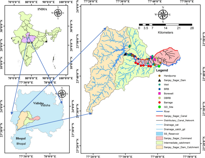
Irrigation is one of the major consumers of fresh water but crops consume only a small part of supplied water and huge quantities emerge downstream as rejuvenated flow and recharge groundwater. The assessment of these flows is cumbersome due to dependence on multiple factors; hence a fixed percentage is assumed by government agencies for designing downstream projects. Three different modeling and measurement techniques, i.e., water balance, isotopic analyses, and hydrological modeling were used to compute surface and sub-surface components of irrigation return flow in an irrigation project (Sanjay Sagar Project with the capacity of 82 MCM and 9863 ha command area) situated in the hard rock region of Central India. The water balance analysis confirmed that a major portion ranging from 12.3 to 35.9%, with an average of 22.9% of supplied water to the command reached the Bah River as regenerated flow, while 1.9–16% with an average of 10.2% of supplied water reached the groundwater body as recharge. The isotopic analysis yielded qualitative insights into the proportional influence of irrigation water on open wells and bore wells in the range of 81% and 9%, respectively. The outcomes of the SWAT model demonstrated that within Sanjay Sagar's command, irrigation led to approximately 27.8% of regenerated flow and 8.9% of recharge from applied irrigation.
中文翻译:
对命令中灌溉回流进行定量评估的监测和建模方法
灌溉是淡水的主要消耗者之一,但农作物只消耗供水的一小部分,大量的水会随着恢复水流和地下水的补给而流向下游。由于依赖于多种因素,对这些流量的评估很麻烦;因此,政府机构在设计下游项目时采用了固定的百分比。使用三种不同的建模和测量技术,即水平衡、同位素分析和水文建模来计算灌溉项目(容量为 82 MCM 和 9863 公顷的 Sanjay Sagar 项目)灌溉回流的地表和地下部分。区)位于印度中部的硬岩地区。水平衡分析证实,指挥部供水的主要部分为再生水流,从 12.3% 到 35.9%,平均为 22.9%,到达巴河,而 1.9% 到 16%,平均为 10.2%。到达地下水体作为补给。同位素分析得出了灌溉水对裸井和钻井的比例影响分别为 81% 和 9% 的定性见解。SWAT 模型的结果表明,在 Sanjay Sagar 的指挥下,灌溉带来了大约 27.8% 的再生流量和 8.9% 的灌溉补给。


 京公网安备 11010802027423号